Difference between revisions of "2020-01-31 52 4"
FelixTheCat (talk | contribs) (Created page with "{{subst:Expedition |lat = 52 |lon = 4 |date = 2020-01-31 }}") |
m (Location) |
||
| (2 intermediate revisions by one other user not shown) | |||
| Line 1: | Line 1: | ||
| − | |||
| − | |||
| − | |||
| − | |||
| − | |||
| − | |||
| − | |||
| − | |||
| − | |||
| − | |||
{{meetup graticule | {{meetup graticule | ||
| lat=52 | | lat=52 | ||
| Line 15: | Line 5: | ||
}} | }} | ||
| − | |||
__NOTOC__ | __NOTOC__ | ||
== Location == | == Location == | ||
| − | + | Voorburg, South Holland province. | |
== Participants == | == Participants == | ||
| − | + | [[User:FelixTheCat|FelixTheCat]] ([[User talk:FelixTheCat|talk]]) | |
| − | |||
| − | |||
| − | |||
| − | |||
== Expedition == | == Expedition == | ||
| − | + | It was a nice sunny Friday, and this hash was within easy cycling distance from my home. So that's what I did: it took about 30 minutes to cover the 9.5 km to the hash, which was located in a park in Voorburg (a leafy suburb of The Hague). The exact point was right next to a little bridge. I took a few pictures, then rode around the area a little. I'm very familiar with this area, as the secondary school I attended is nearby. I then went to do some shopping before riding home again. | |
| − | |||
| − | |||
| − | |||
== Photos == | == Photos == | ||
| − | |||
| − | |||
| − | |||
<gallery perrow="5"> | <gallery perrow="5"> | ||
| + | Image:2020-01-31_52_4_FelixTheCat_1.JPG | Parked my bike near the hash. The sign says "no dogs allowed", but that didn't stop one gentleman from walking his dog right there about one minute later. | ||
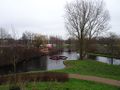
| + | Image:2020-01-31_52_4_FelixTheCat_2.JPG | The hash is right here, next to the bridge. | ||
| + | Image:2020-01-31_52_4_FelixTheCat_3.png | Made it! | ||
| + | Image:2020-01-31_52_4_FelixTheCat_4.JPG | Lloyd posing at the hash. | ||
| + | Image:2020-01-31_52_4_FelixTheCat_5.JPG | An interesting type of birdhouse nearby. | ||
| + | Image:2020-01-31_52_4_FelixTheCat_6.JPG | A bit further on, there is an artificial hill. Here we're looking directly at the hash from the top. | ||
</gallery> | </gallery> | ||
== Achievements == | == Achievements == | ||
{{#vardefine:ribbonwidth|800px}} | {{#vardefine:ribbonwidth|800px}} | ||
| − | + | {{bicycle geohash | |
| − | + | | latitude = 52 | |
| − | + | | longitude = 4 | |
| − | + | | date = 2020-01-31 | |
| − | [[ | + | | name = [[User:FelixTheCat|FelixTheCat]] ([[User talk:FelixTheCat|talk]]) |
| − | + | | distance = 9.5km | |
| − | + | }} | |
| − | |||
| − | |||
| − | |||
| − | [[ | ||
| − | |||
| − | |||
| − | |||
| − | |||
| − | |||
[[Category:Expeditions]] | [[Category:Expeditions]] | ||
| − | |||
[[Category:Expeditions with photos]] | [[Category:Expeditions with photos]] | ||
| − | |||
| − | |||
| − | |||
| − | |||
| − | |||
[[Category:Coordinates reached]] | [[Category:Coordinates reached]] | ||
| − | + | {{location|NL|ZH}} | |
| − | |||
| − | |||
| − | |||
| − | |||
| − | |||
| − | |||
| − | |||
| − | |||
| − | |||
| − | |||
| − | |||
| − | |||
| − | |||
| − | |||
| − | |||
| − | |||
| − | |||
Revision as of 18:26, 16 February 2020
| Fri 31 Jan 2020 in 52,4: 52.0805981, 4.3579506 geohashing.info google osm bing/os kml crox |
Location
Voorburg, South Holland province.
Participants
Expedition
It was a nice sunny Friday, and this hash was within easy cycling distance from my home. So that's what I did: it took about 30 minutes to cover the 9.5 km to the hash, which was located in a park in Voorburg (a leafy suburb of The Hague). The exact point was right next to a little bridge. I took a few pictures, then rode around the area a little. I'm very familiar with this area, as the secondary school I attended is nearby. I then went to do some shopping before riding home again.
Photos
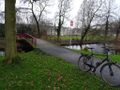
Parked my bike near the hash. The sign says "no dogs allowed", but that didn't stop one gentleman from walking his dog right there about one minute later.
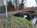
The hash is right here, next to the bridge.
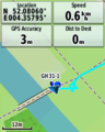
Made it!
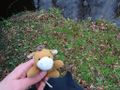
Lloyd posing at the hash.
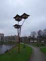
An interesting type of birdhouse nearby.
A bit further on, there is an artificial hill. Here we're looking directly at the hash from the top.


Achievements
FelixTheCat (talk) earned the Bicycle geohash achievement
|