Difference between revisions of "2020-02-10 35 -105"
(It's just crazy enough to work) |
m (holding off on last hasher standing for now obvs) |
||
| Line 1: | Line 1: | ||
| + | |||
| + | <!-- If you did not specify these parameters in the template, please substitute appropriate values for IMAGE, LAT, LON, and DATE (YYYY-MM-DD format) | ||
| + | |||
| + | [[Image:{{{image|IMAGE}}}|thumb|left]] | ||
| + | |||
| + | Remove this section if you don't want an image at the top (left) of your report. You should remove the "Image:" or "File:" | ||
| + | tag from your image file name, and replace the all upper-case word IMAGE in the above line. | ||
| + | |||
| + | And DON'T FORGET to add your expedition and the best photo you took to the gallery on the Main Page! We'd love to read your report, but that means we first have to discover it! :) | ||
| + | --> | ||
| + | {{meetup graticule | ||
| + | | lat=35 | ||
| + | | lon=-105 | ||
| + | | date=2020-02-10 | ||
| + | }} | ||
| + | |||
| + | <!-- edit as necessary --> | ||
| + | __NOTOC__ | ||
| + | |||
| + | == Location == | ||
| + | <!-- where you've surveyed the hash to be --> | ||
| + | |||
| + | == Participants == | ||
| + | <!-- who attended: If you link to your wiki user name in this section, your expedition will be picked up by the various statistics generated for geohashing. You may use three tildes ~ as a shortcut to automatically insert the user signature of the account you are editing with. | ||
| + | --> | ||
| + | |||
== Plans == | == Plans == | ||
| − | + | <!-- what were the original plans --> | |
| + | |||
| + | == Expedition == | ||
| + | <!-- how it all turned out. your narrative goes here. --> | ||
| + | |||
| + | == Tracklog == | ||
| + | <!-- if your GPS device keeps a log, you may post a link here --> | ||
| + | |||
| + | == Photos == | ||
| + | <!-- Insert pictures between the gallery tags using the following format: | ||
| + | Image:2012-##-## ## ## Alpha.jpg | Witty Comment | ||
| + | --> | ||
| + | <gallery perrow="5"> | ||
| + | </gallery> | ||
| + | |||
| + | == Achievements == | ||
| + | {{#vardefine:ribbonwidth|800px}} | ||
| + | <!-- Add any achievement ribbons you earned below, or remove this section --> | ||
| + | |||
| + | <!-- =============== USEFUL CATEGORIES FOLLOW ================ | ||
| + | Delete the next line ONLY if you have chosen the appropriate categories below. If you are unsure, don't worry. People will read your report and help you with the classification. --> | ||
| + | [[Category:New report]] | ||
| + | |||
| + | <!-- ==REQUEST FOR TWITTER BOT== Please leave either the New report or the Expedition planning category in as long as you work on it. This helps the twitter bot a lot with announcing the right outcome at the right moment. --> | ||
| + | |||
| + | <!-- Potential categories. Please include all the ones appropriate to your expedition --> | ||
| + | <!-- If this is a planning page: | ||
| + | [[Category:Expedition planning]] | ||
| + | --> | ||
| + | |||
| + | <!-- If all those plans are never acted upon, change [[Category:Expedition planning]] to [[Category:Not reached - Did not attempt]]. --> | ||
| + | |||
| + | <!-- An actual expedition: | ||
| + | [[Category:Expeditions]] | ||
| + | -- and one or more of -- | ||
| + | [[Category:Expeditions with photos]] | ||
| + | [[Category:Expeditions with videos]] | ||
| + | [[Category:Expedition without GPS]] | ||
| + | --> | ||
| + | |||
| + | <!-- if you reached your coords: | ||
| + | [[Category:Coordinates reached]] | ||
| + | |||
| + | |||
| + | --><!-- or if you failed :( | ||
| + | [[Category:Coordinates not reached]] | ||
| + | -- and a reason -- | ||
| + | When there is a natural obstacle between you and the target: | ||
| + | [[Category:Not reached - Mother Nature]] | ||
| + | |||
| + | When there is a man-made obstacle between you and the target: | ||
| + | [[Category:Not reached - No public access]] | ||
| + | |||
| + | When you failed get your GPS, car, bike or such to work: | ||
| + | [[Category:Not reached - Technology]] | ||
| + | |||
| + | When you went to an alternate location instead of the actual geohash: | ||
| + | [[Category:Not reached - Attended alternate location]] | ||
| + | |||
| + | (Don't forget to delete this final close comment marker) --> | ||
| + | |||
| + | |||
| + | == Plans == | ||
| + | I ([[user:Arlo]]) decided to check geohashing.info mostly out of curiosity rather than expectation, and found out that the hash is within walking distance of me. However, I already have plans to be picked up by car not long after the time I checked, so I'll try to convince the driver to swing over to the hash instead (another time, [[hobbit achievement]]). | ||
| + | The location: dead in the middle of Sicomoro Street, a short residential stub off of West Alameda. The public nature that made it so convenient rules out the wackier achievements, but I'll be able to snap a couple pictures. | ||
| + | |||
| + | == Results == | ||
| + | Success! Pretty basic hash because it's zero preparation, but I got what I needed: proof, and a tracklog ([[:file:2020-02-10_35_-105.gpx.xml]] a.k.a. [[osmuser:Arlo%20James%20Barnes/traces/3206913]]). Then I went across town to the Center for Contemporary Arts to see if they really did rip that big installation art structure that was used for skygazing out of the ground, and damned if they didn't. | ||
| + | |||
| + | == Proof == | ||
| + | <gallery perrow="3"> | ||
| + | file:2020-02-10_grin.jpg|The Grin. Kinda more of a smirk maybe. | ||
| + | file:2020-02-10_approaching.jpg|Turning on to Sicomoro (taken at the same time as the Grin while waiting for traffic to pass. | ||
| + | file:2020-02-10_hashpoint.jpg|We parked on the opposite side of the street from a moving van in someone's driveway. | ||
| + | <!--file:.jpg|--> | ||
| + | </gallery> | ||
| + | |||
| + | == Achievements == | ||
| + | |||
| + | {{OpenStreetMap achievement | ||
| + | |latitude=35 | ||
| + | |longitude=-105 | ||
| + | |date=2020-02-10 | ||
| + | |OSMlink=80822486 | ||
| + | |name=Arlo | ||
| + | |image=2020-02-10_grin.jpg<!--file:2020-02-10_35_-105.gpx.xml--> | ||
| + | }} | ||
| + | <!--{{last man standing | ||
| + | |latitude=35 | ||
| + | |longitude=-105 | ||
| + | |date=2020-02-10 | ||
| + | |gender=hasher | ||
| + | |name=Arlo | ||
| + | |image=2020-02-10_grin.jpg<!--file:2020-02-10_35_-105.gpx.xml--> | ||
| + | }}--> | ||
| + | |||
| + | [[category:coordinates reached]] | ||
| + | [[category:expeditions with photos]] | ||
Revision as of 03:57, 11 February 2020
| Mon 10 Feb 2020 in 35,-105: 35.6869406, -105.9645191 geohashing.info google osm bing/os kml crox |
Location
Participants
Plans
Expedition
Tracklog
Photos
Achievements
Plans
I (user:Arlo) decided to check geohashing.info mostly out of curiosity rather than expectation, and found out that the hash is within walking distance of me. However, I already have plans to be picked up by car not long after the time I checked, so I'll try to convince the driver to swing over to the hash instead (another time, hobbit achievement). The location: dead in the middle of Sicomoro Street, a short residential stub off of West Alameda. The public nature that made it so convenient rules out the wackier achievements, but I'll be able to snap a couple pictures.
Results
Success! Pretty basic hash because it's zero preparation, but I got what I needed: proof, and a tracklog (file:2020-02-10_35_-105.gpx.xml a.k.a. osmuser:Arlo James Barnes/traces/3206913). Then I went across town to the Center for Contemporary Arts to see if they really did rip that big installation art structure that was used for skygazing out of the ground, and damned if they didn't.
Proof

The Grin. Kinda more of a smirk maybe.
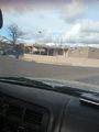
Turning on to Sicomoro (taken at the same time as the Grin while waiting for traffic to pass.
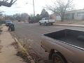
We parked on the opposite side of the street from a moving van in someone's driveway.


Achievements
Arlo earned the OpenStreetMap achievement
|
}}-->