Difference between revisions of "2020-02-10 35 -105"
m (holding off on last hasher standing for now obvs) |
m (redundant) |
||
| (6 intermediate revisions by 2 users not shown) | |||
| Line 1: | Line 1: | ||
| + | <!-- | ||
| + | [[file:{{{image|2020-02-10_35_-105.gpx.xml}}}|thumb|left]] | ||
| + | --> | ||
| − | |||
| − | |||
| − | |||
| − | |||
| − | |||
| − | |||
| − | |||
| − | |||
| − | |||
{{meetup graticule | {{meetup graticule | ||
| − | | lat=35 | + | |lat=35 |
| − | | lon=-105 | + | |lon=-105 |
| − | | date=2020-02-10 | + | |date=2020-02-10 |
}} | }} | ||
| − | |||
__NOTOC__ | __NOTOC__ | ||
== Location == | == Location == | ||
| − | + | Dead in the middle of Sicomoro Street, a short residential stub off of West Alameda. The public nature that made it so convenient rules out the wackier achievements, but I'll be able to snap a couple pictures. | |
== Participants == | == Participants == | ||
| − | + | * [[user:Arlo]] | |
| − | |||
== Plans == | == Plans == | ||
| − | + | I ([[user:Arlo]]) decided to check geohashing.info mostly out of curiosity rather than expectation, and found out that the hash is within walking distance of me. However, I already have plans to be picked up by car not long after the time I checked, so I'll try to convince the driver to swing over to the hash instead (another time, [[hobbit achievement]]). | |
== Expedition == | == Expedition == | ||
| − | + | Success! Pretty basic hash because it's zero preparation, but I got what I needed: proof, and a tracklog (see next section). Then I went across town to the Center for Contemporary Arts to see if they really did rip that big installation art structure that was used for skygazing out of the ground, and damned if they didn't. | |
== Tracklog == | == Tracklog == | ||
| − | |||
| − | + | {{tracklog | |
| − | + | |2020-02-10_35_-105.gpx.xml}} | |
| − | |||
| − | |||
| − | |||
| − | |||
| − | |||
| − | |||
| − | |||
| − | |||
| − | + | a.k.a. [[osmuser:Arlo%20James%20Barnes/traces/3206913]] | |
| − | |||
| − | [[ | ||
| − | + | == Photos == | |
| − | |||
| − | |||
| − | |||
| − | |||
| − | |||
| − | |||
| − | |||
| − | |||
| − | |||
| − | |||
| − | |||
| − | |||
| − | |||
| − | |||
| − | |||
| − | |||
| − | |||
| − | |||
| − | |||
| − | |||
| − | |||
| − | |||
| − | |||
| − | |||
| − | |||
| − | |||
| − | |||
| − | |||
| − | |||
| − | |||
| − | |||
| − | |||
| − | |||
| − | |||
| − | |||
| − | |||
| − | |||
| − | |||
| − | |||
| − | |||
| − | |||
| − | |||
| − | |||
| − | |||
| − | |||
| − | |||
<gallery perrow="3"> | <gallery perrow="3"> | ||
file:2020-02-10_grin.jpg|The Grin. Kinda more of a smirk maybe. | file:2020-02-10_grin.jpg|The Grin. Kinda more of a smirk maybe. | ||
| − | file:2020-02-10_approaching.jpg|Turning on to Sicomoro (taken at the same time as the Grin while waiting for traffic to pass. | + | file:2020-02-10_approaching.jpg|Turning on to Sicomoro (taken at the same time as the Grin while waiting for traffic to pass). |
file:2020-02-10_hashpoint.jpg|We parked on the opposite side of the street from a moving van in someone's driveway. | file:2020-02-10_hashpoint.jpg|We parked on the opposite side of the street from a moving van in someone's driveway. | ||
<!--file:.jpg|--> | <!--file:.jpg|--> | ||
| Line 104: | Line 39: | ||
== Achievements == | == Achievements == | ||
| − | + | {{#vardefine:ribbonwidth|800px}} | |
{{OpenStreetMap achievement | {{OpenStreetMap achievement | ||
|latitude=35 | |latitude=35 | ||
| Line 110: | Line 45: | ||
|date=2020-02-10 | |date=2020-02-10 | ||
|OSMlink=80822486 | |OSMlink=80822486 | ||
| + | |OSMlink2=80881561 | ||
|name=Arlo | |name=Arlo | ||
|image=2020-02-10_grin.jpg<!--file:2020-02-10_35_-105.gpx.xml--> | |image=2020-02-10_grin.jpg<!--file:2020-02-10_35_-105.gpx.xml--> | ||
}} | }} | ||
| − | + | {{last man standing | |
|latitude=35 | |latitude=35 | ||
|longitude=-105 | |longitude=-105 | ||
| Line 120: | Line 56: | ||
|name=Arlo | |name=Arlo | ||
|image=2020-02-10_grin.jpg<!--file:2020-02-10_35_-105.gpx.xml--> | |image=2020-02-10_grin.jpg<!--file:2020-02-10_35_-105.gpx.xml--> | ||
| − | }} | + | }} |
| + | [[category:expeditions]] | ||
[[category:coordinates reached]] | [[category:coordinates reached]] | ||
[[category:expeditions with photos]] | [[category:expeditions with photos]] | ||
| + | {{location|US|NM|ST}} | ||
Latest revision as of 08:47, 31 August 2020
| Mon 10 Feb 2020 in 35,-105: 35.6869406, -105.9645191 geohashing.info google osm bing/os kml crox |
Location
Dead in the middle of Sicomoro Street, a short residential stub off of West Alameda. The public nature that made it so convenient rules out the wackier achievements, but I'll be able to snap a couple pictures.
Participants
Plans
I (user:Arlo) decided to check geohashing.info mostly out of curiosity rather than expectation, and found out that the hash is within walking distance of me. However, I already have plans to be picked up by car not long after the time I checked, so I'll try to convince the driver to swing over to the hash instead (another time, hobbit achievement).
Expedition
Success! Pretty basic hash because it's zero preparation, but I got what I needed: proof, and a tracklog (see next section). Then I went across town to the Center for Contemporary Arts to see if they really did rip that big installation art structure that was used for skygazing out of the ground, and damned if they didn't.
Tracklog
a.k.a. osmuser:Arlo James Barnes/traces/3206913
Photos

The Grin. Kinda more of a smirk maybe.
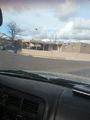
Turning on to Sicomoro (taken at the same time as the Grin while waiting for traffic to pass).
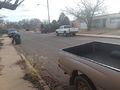
We parked on the opposite side of the street from a moving van in someone's driveway.


Achievements
Arlo earned the OpenStreetMap achievement
|
Arlo earned the Last hasher standing achievement
|