Difference between revisions of "2020-02-21 51 -1"
(→Expedition) |
|||
| Line 20: | Line 20: | ||
== Expedition == | == Expedition == | ||
<!-- how it all turned out. your narrative goes here. --> | <!-- how it all turned out. your narrative goes here. --> | ||
| − | + | I drove out to the village of Curbridge and parked in a lane, then walked to the hashpoint, arriving about 13:05. Conveniently there's a pole (holding a speed detecting sign) within a metre of the hashpoint so I was able to attach a "The Internet Was Here" sign in accordance with the tradition. Then I made my way to a coworking space half a mile to the North to carry on with my day's work. | |
| − | 13:05 | ||
== Tracklog == | == Tracklog == | ||
| − | + | * Obtained, but I didn't bring the right cable to the coworking space so I can't get it yet. | |
== Photos == | == Photos == | ||
| − | + | Extracted from the video: | |
| − | + | ||
| − | |||
<gallery perrow="5"> | <gallery perrow="5"> | ||
| + | Image:2020-02-21 51 -1 001.png | Proof | ||
| + | Image:2020-02-21 51 -1 002.png | Sign | ||
| + | Image:2020-02-21 51 -1 003.png | Sillyish grin | ||
</gallery> | </gallery> | ||
| + | |||
| + | == Video == | ||
| + | A 3-minute video of the expedition can be seen: | ||
| + | * [https://tube.danq.me/videos/watch/e36d2497-5fb5-44b3-87dc-136faa861b26 On QTube] | ||
== Achievements == | == Achievements == | ||
| Line 37: | Line 42: | ||
<!-- Add any achievement ribbons you earned below, or remove this section --> | <!-- Add any achievement ribbons you earned below, or remove this section --> | ||
| − | |||
| − | |||
| − | |||
| − | |||
| − | |||
| − | |||
| − | |||
| − | |||
| − | |||
| − | |||
| − | |||
| − | |||
| − | |||
| − | |||
[[Category:Expeditions]] | [[Category:Expeditions]] | ||
| − | |||
[[Category:Expeditions with photos]] | [[Category:Expeditions with photos]] | ||
[[Category:Expeditions with videos]] | [[Category:Expeditions with videos]] | ||
| − | |||
| − | |||
| − | |||
| − | |||
[[Category:Coordinates reached]] | [[Category:Coordinates reached]] | ||
| − | |||
| − | |||
| − | |||
| − | |||
| − | |||
| − | |||
| − | |||
| − | |||
| − | |||
| − | |||
| − | |||
| − | |||
| − | |||
| − | |||
| − | |||
| − | |||
| − | |||
| − | |||
__NOTOC__ | __NOTOC__ | ||
Revision as of 14:05, 21 February 2020
| Have you seen our geohashing marker? We'd love to hear from you! Click here to say "hi" and tell us what you've seen!
Curious about what geohashing is? Read more! |
| Fri 21 Feb 2020 in 51,-1: 51.7778341, -1.5234418 geohashing.info google osm bing/os kml crox |
Location
North end of the village of Curbridge in Oxfordshire. Street View and satellite photography shows it as being alongside a nondescript road, but I'm aware that there's a housing estate under construction nearby and there's a new roundabout which appears on maps but not on satellite views which was constructed nearby last year: I'm hoping that the location is still accessible.
Participants
Plans
I don't know whether I'll be able to make it to this hashpoint; it depends on how work goes as well as the weather (while I'm not directly in the path of Storm Dennis I'm still in an area that's getting lots of wind and rain). I'm not committed yet to whether I'd drive or cycle: it depends on how long I can spare, whether the car's available for my use, and - again - the weather (I'd prefer to cycle, but I'm not going to do it if it means I get completely soaked on my lunch break).
Okay: I need to vacate my house anyway because some estate agents are bring some potential buyers around, so I'm setting out to the hashpoint now (12:20) after which I'll aim to work in a coworking space for the afternoon. Wish me luck!
Expedition
I drove out to the village of Curbridge and parked in a lane, then walked to the hashpoint, arriving about 13:05. Conveniently there's a pole (holding a speed detecting sign) within a metre of the hashpoint so I was able to attach a "The Internet Was Here" sign in accordance with the tradition. Then I made my way to a coworking space half a mile to the North to carry on with my day's work.
Tracklog
- Obtained, but I didn't bring the right cable to the coworking space so I can't get it yet.
Photos
Extracted from the video:
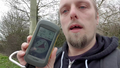
Proof
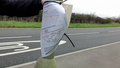
Sign

Sillyish grin


Video
A 3-minute video of the expedition can be seen: