Difference between revisions of "2020-02-29 44 -79"
From Geohashing
m (More specific location) |
m |
||
| Line 40: | Line 40: | ||
</gallery> | </gallery> | ||
| + | [[Category:Expeditions]] | ||
| + | [[Category:Expeditions with photos]] | ||
| + | [[Category:Coordinates reached]] | ||
{{location|CA|ON|SC}} | {{location|CA|ON|SC}} | ||
| − | |||
Latest revision as of 10:38, 24 September 2021
| Sat 29 Feb 2020 in 44,-79: 44.0713524, -79.6336988 geohashing.info google osm bing/os kml crox |
Location
A field near Highway 404
Participants
- SIGSTKFLT
- SIGSTKFLT'S mom
Plans
Acquire a Leap geohash.
Expedition
SIGSTKFLT
We (mom and I) Should™ be there around 4pm. --SIGSTKFLT (talk) 18:36, 29 February 2020 (UTC)

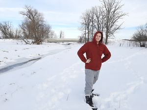
Me and a nearby road bridge
After surviving an entire 15 minute drive, we arrived and parked just before the bridge. We braved some deep snow and a barbed wire fence before arriving at the hashpoint.
SIGSTKFLT earned the Land geohash achievement
|
SIGSTKFLT earned the Leap geohash achievement 2020
by leaping to the hash point on leap day of the year 2020.
SIGSTKFLT earned the Frozen Geohash Achievement
by reaching the (44, -79) geohash on 2020-02-29 while the temperature was -11°C.


