2020-03-19 42 -78
| Thu 19 Mar 2020 in 42,-78: 42.1282974, -78.7145168 geohashing.info google osm bing/os kml crox |
Location
Next to the Bear Paw trail by the Stone Tower in Allegany State Park
Participants
- Pedalpusher
- Simon the dog
- Myka the dog
Expedition
A day after getting back from North Carolina and completing an expedition in Altoona, I'm heading to Allegany State Park (ASP) for another Geohash to attempt to start a Consecutive Streak.
After finishing up with work, I got things together, and with the dogs, we were on the road a little after 17:00. Sunset was at 19:23 and with about an hour drive, I needed to make sure I had enough sunlight to get to the hash and back. Plus, there was an old Geohash that landed pretty close to the Stone Tower and I think about it every time I drive into ASP. I should be able to capture this Retro-Hash after getting to today's point.
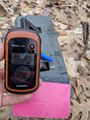
With COVID-19 ongoing, not a lot of people are out-and-about so it was an easy drive to ASP. I parked in the Summit parking lot and let the dogs out of the car. With no one around, they were very excited to run around and explore. Walking down the Stone Tower Road, I kept my eyes out for the Bear Paw trail in the woods. It's a newer trail and I didn't know where the Trailheads were, but I recall seeing the Trail Markers from the road in the past. About half way down to the tower, I turned on the GPS and shortly after, I saw a Trail Marker off to the Left (the side with the Hash). I cut through the woods and followed the trail to the hash. I was thinking I would need to go off the trail (per Open Streetmaps) but the GPS said the hash was right next to the trail. Doing a short GPS dance, I got a good reading and took some pictures.
I then continued on the trail toward the Stone Tower on the lookout for the GeoCache that was close to the Tower for a Hash Collision Honorable Mention. Locating the Geocache, I signed the log and took some additional pictures for the Collision ribbon. Replacing the Cache, I went over to the Stone tower and admired the view for a moment. The dogs were bored up there so we started down the road to the 2017-12-31 Geohash.
On the way back to the car, we continued back on the Bear Paw trail where it crossed the road by the Stone Tower. I'm planning on completing all the hiking trails in ASP in the next 2 years but this one was a quandary as I didn't know where this one started and ended. As we were walking back, I noticed another Geocache container right next to a tree abutting the trail. Even though I 'muggled' this cache, I still opened it up and signed the log. This one was also within the Honorable Mention distance of the Hash but I didn't take any pictures for this one. Note: As I write this up, I looked up this second GeoCache and I think it was in the wrong spot. The Coordinates for it is the Starting Point and not the cache itself and that might be out of range if it was in the correct spot. This has been noted on the Cache page.
Getting to the end of the trail by the parking lot, I noted where this side of the trail starts. For my Completionist Hiking, I can start on this side of the trail and walk the whole thing and I'll then find out where the other side starts/ends.
Getting back to the car, I noticed that we timed this adventure quite well, with about 10 minutes of daylight left, we headed for home.
While there was another Geohash that I probably could have gotten to on 2020-03-20 by the Allegany river (again near ASP), I decided against another long drive to continue the Consecutive streak so that ends at 2.
Photos
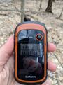
Made it!
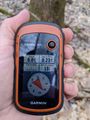
Accuracy.
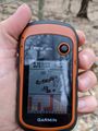
Distance at the Hash to the Cache for the Hash Collision event.

Dogs sitting nicely for their Picture at the Hash.
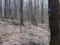
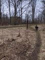
View of the Hash (on the left) from the trail.

Happy to make it!
Found the Cache. Distance back to the Hash from the Cache.
Getting out of the woods, we can see the Stone Tower.
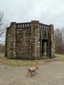
Walking around the Stone Tower.
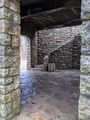
The first floor of the tower is open but there are steps to get to the second floor.
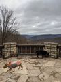
View from the tower overlooking Salamanca.
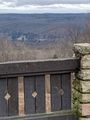
Looking the other way, you can see the Red House Admin building and the Dam for Red House Lake.
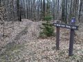
Found the Trailhead for Bear Paw when I come back and hike the full trail.


Ribbons
This user earned the Land geohash achievement
|
Pedalpusher earned the Consecutive geohash achievement
|
Pedalpusher earned the Hash collision honorable mention
|