2020-05-13 42 -78
| Wed 13 May 2020 in 42,-78: 42.9929843, -78.2072371 geohashing.info google osm bing/os kml crox |
Location
Eastern edge of Batavia, next to Treadeasy Ave.
Participants
- Pedalpusher
- Simon the dog
- Myka the dog
Expedition
I might not have gone for this one normally, but we are in the middle of a Pandemic and what else is there to do. Also, this would capture the #92 square in my Buffalo Centicule Map. I don't like driving this far just for a stop-and-go so to make the drive worth it, I figured I could take the dogs and we could stop at Darien Lakes State Park for a bit and hike around afterwords.
It was a very nice day and the drive out after work was uneventful. I'm glad I had the Phone GPS running though when I got to Batavia because the turn came up quick and was not well marked. I would have driven right by it otherwise. Getting to the hash area, there was a guy walking down the road and it just happened he was walking right next to the hash when I got there. I had to go slow around him so he would be out of the way as he was walking where I wanted to park. Traffic Jam averted, I hopped out of the car and let the dogs out to stretch their legs. This was pretty much an empty field in and industrial area so I didn't think anyone would even see, let alone care.
Walking over to the hash area, I got a decent reading on the Hash-droid app and took a few pictures of the area. Success had, we got back in the car and drove the 15 minutes back to the State Park. I was surprised at how full the parking lot was, but was also happy to see the 3 horse trailers leaving as I parked. I figured everyone would be hiking on the Finger Lakes Trail so I chose to walk the other way on the Horse Trails now that there was little chance of running into them. Turns out there were plenty of people on the horse trails too, but they were plenty wide enough and we gave each other a wide berth as we passed other hikers. We walked for about 40 minutes before turning around and I fed the dogs in the car before heading out. I then decided to stop at The Pink Cow for some ice cream in Alden before driving the rest of the way home. Since it was late (20:00) my Medium Mint ice cream cone was my dinner this evening.
Photos
Made it!
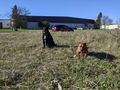
Simon is getting good at the Stupid Grin at the hash.
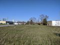
View East from the Hash.
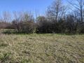
Walking back to the car, a view of the hash.
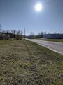
View West down the road. The guy walking is now too far down the road to see.
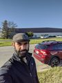
My own Stupid Grin before we jumped back in the Hash-mobile to go for our hike.


Ribbons
This user earned the Land geohash achievement
|