Difference between revisions of "2020-05-19 47 -122"
([live picture]driveway? [https://openstreetmap.org/?lat=47.76390230&lon=-122.24210110&zoom=16&layers=B000FTF @47.7639,-122.2421]) |
|||
| Line 1: | Line 1: | ||
| − | + | {{meetup graticule | |
| − | |||
| − | |||
| − | |||
| − | |||
| − | |||
| − | |||
| − | |||
| − | |||
| lat=47 | | lat=47 | ||
| lon=-122 | | lon=-122 | ||
| date=2020-05-19 | | date=2020-05-19 | ||
| + | | graticule_name=Seattle | ||
| + | | graticule_link=Seattle, Washington | ||
}}<!-- edit as necessary --> | }}<!-- edit as necessary --> | ||
__NOTOC__ | __NOTOC__ | ||
== Location == | == Location == | ||
| − | + | In the wetlands alongside Swamp Creek in Kenmore. | |
== Participants == | == Participants == | ||
| − | + | * [[User:Thomcat|Thomcat]] | |
| − | |||
== Plans == | == Plans == | ||
| − | + | Drove past this countless times on the way to work. Since I have to make a special trip today anyways... | |
== Expedition == | == Expedition == | ||
| − | + | I've worked for one company for 20 years now, and driven past this location for a significant percentage of those years - though not the last few months, obviously. Swamp Creek was largely taken over by local residents, though any heavy rain would prove otherwise. In fact, two houses on this road no longer exist, having been torn down by the city who acquired the property to return to wetlands. | |
| + | |||
| + | The geohashpoint was not in the properties (no longer dry) of either of those houses, though. It was more than 60 yards off the road, and this being a wetland, I wasn't sure what I would encounter. Worth a walk, as they say. | ||
| + | |||
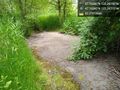
| + | The first part (and the last photo below) was paved - perhaps it was once a driveway, or sidewalk? An animal trail led off that in the direction of the hashpoint, so we followed that. My daughter has been a dragalong for geohash since I started this - man, that was a lot of years ago! | ||
| + | |||
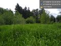
| + | Continuing east, we found tires, spiders, and lots of 4' or 5' tall marsh grasses - but no running water. We could hear it, though, further east - what shows on the map as Swamp Creek proper. | ||
| + | |||
| + | Finally, the app announced that we arrived (20 meters away). I kept going until nearly 10 meters away, but the point bounced each time I snapped a picture. Opting for discretion, I called it a success and retraced my steps. I don't think we stepped on anything larger than an insect - but no point in continuing to take chances. Our trodden grass trail is probably disturbing enough. | ||
| + | |||
| + | A fun expedition on a nice day. | ||
== Tracklog == | == Tracklog == | ||
| Line 46: | Line 49: | ||
== Achievements == | == Achievements == | ||
{{#vardefine:ribbonwidth|800px}} | {{#vardefine:ribbonwidth|800px}} | ||
| − | |||
| − | |||
| − | |||
| − | |||
| − | |||
| − | |||
| − | |||
| − | |||
| − | |||
| − | |||
| − | |||
| − | |||
| − | |||
| − | |||
| − | |||
[[Category:Expeditions]] | [[Category:Expeditions]] | ||
| − | |||
[[Category:Expeditions with photos]] | [[Category:Expeditions with photos]] | ||
| − | |||
| − | |||
| − | |||
| − | |||
| − | |||
[[Category:Coordinates reached]] | [[Category:Coordinates reached]] | ||
| − | + | {{location|US|WA|KI}} | |
| − | |||
| − | |||
| − | |||
| − | |||
| − | |||
| − | |||
| − | |||
| − | |||
| − | |||
| − | |||
| − | |||
| − | |||
| − | |||
| − | |||
| − | |||
| − | |||
| − | |||
Revision as of 23:14, 19 May 2020
| Tue 19 May 2020 in Seattle: 47.7638043, -122.2414042 geohashing.info google osm bing/os kml crox |
Location
In the wetlands alongside Swamp Creek in Kenmore.
Participants
Plans
Drove past this countless times on the way to work. Since I have to make a special trip today anyways...
Expedition
I've worked for one company for 20 years now, and driven past this location for a significant percentage of those years - though not the last few months, obviously. Swamp Creek was largely taken over by local residents, though any heavy rain would prove otherwise. In fact, two houses on this road no longer exist, having been torn down by the city who acquired the property to return to wetlands.
The geohashpoint was not in the properties (no longer dry) of either of those houses, though. It was more than 60 yards off the road, and this being a wetland, I wasn't sure what I would encounter. Worth a walk, as they say.
The first part (and the last photo below) was paved - perhaps it was once a driveway, or sidewalk? An animal trail led off that in the direction of the hashpoint, so we followed that. My daughter has been a dragalong for geohash since I started this - man, that was a lot of years ago!
Continuing east, we found tires, spiders, and lots of 4' or 5' tall marsh grasses - but no running water. We could hear it, though, further east - what shows on the map as Swamp Creek proper.
Finally, the app announced that we arrived (20 meters away). I kept going until nearly 10 meters away, but the point bounced each time I snapped a picture. Opting for discretion, I called it a success and retraced my steps. I don't think we stepped on anything larger than an insect - but no point in continuing to take chances. Our trodden grass trail is probably disturbing enough.
A fun expedition on a nice day.
Tracklog
Photos

accuracy @47.7640,-122.2413

geohasher @47.7639,-122.2414
area @47.7639,-122.2414
driveway? @47.7639,-122.2421


