Difference between revisions of "2020-05-21 47 -122"
([live picture]geohasher [https://openstreetmap.org/?lat=47.75405470&lon=-122.38097930&zoom=16&layers=B000FTF @47.7541,-122.3810]) |
(expedition) |
||
| Line 15: | Line 15: | ||
== Plans == | == Plans == | ||
| − | Lunchtime drive. Google street view has for sale sign; Zillow says last sale was 2011. Fingers crossed | + | Lunchtime drive. Google street view has for sale sign; Zillow says last sale was 2011. Fingers crossed. |
== Expedition == | == Expedition == | ||
| − | + | Happy Geohashing Day from Seattle! | |
| + | |||
| + | No problems finding the location, though my car GPS insisted the road had a different name. I would research that if I were interested - but other things to do! | ||
| + | |||
| + | The house was *not* for sale, of course. They and the house across the street had signs for their school graduates. I snapped one photo and moved on to the alternate expedition. | ||
| + | |||
| + | In researching places to hike down to the ocean, I came across the Iris Trailhead, near Innis Arden. A short hike, culminating in a tunnel under railroad tracks to the beach. Found the trailhead easily. | ||
| + | |||
| + | There was a *lot* of mud on the trail - I slipped and fell multiple times on the way down. When I reached the bottom, no tunnel, no "beach", just a bunch of rocks at low tide. Further research on this is interesting, along with a return visit after it has had a chance to dry out - maybe August. | ||
| + | |||
| + | Expedition failed to reach the geohash point, but I had a good time - and that is the real point. Success! | ||
== Tracklog == | == Tracklog == | ||
| Line 40: | Line 50: | ||
<!-- Add any achievement ribbons you earned below, or remove this section --> | <!-- Add any achievement ribbons you earned below, or remove this section --> | ||
| − | |||
| − | |||
| − | |||
[[Category:Expeditions]] | [[Category:Expeditions]] | ||
[[Category:Expeditions with photos]] | [[Category:Expeditions with photos]] | ||
| − | |||
| − | |||
| − | |||
| − | |||
| − | |||
| − | |||
[[Category:Coordinates not reached]] | [[Category:Coordinates not reached]] | ||
| − | |||
[[Category:Not reached - No public access]] | [[Category:Not reached - No public access]] | ||
| − | + | {{location|US|WA|SN}} | |
| − | |||
| − | |||
| − | {{location|US|WA| | ||
Latest revision as of 21:30, 21 May 2020
| Thu 21 May 2020 in Seattle: 47.7868455, -122.3486128 geohashing.info google osm bing/os kml crox |
Location
Private property - back yard of 8527 Madrona Ln in Edmonds
Participants
Plans
Lunchtime drive. Google street view has for sale sign; Zillow says last sale was 2011. Fingers crossed.
Expedition
Happy Geohashing Day from Seattle!
No problems finding the location, though my car GPS insisted the road had a different name. I would research that if I were interested - but other things to do!
The house was *not* for sale, of course. They and the house across the street had signs for their school graduates. I snapped one photo and moved on to the alternate expedition.
In researching places to hike down to the ocean, I came across the Iris Trailhead, near Innis Arden. A short hike, culminating in a tunnel under railroad tracks to the beach. Found the trailhead easily.
There was a *lot* of mud on the trail - I slipped and fell multiple times on the way down. When I reached the bottom, no tunnel, no "beach", just a bunch of rocks at low tide. Further research on this is interesting, along with a return visit after it has had a chance to dry out - maybe August.
Expedition failed to reach the geohash point, but I had a good time - and that is the real point. Success!
Tracklog
Photos

House, not for sale @47.7865,-122.3488
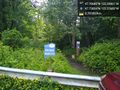
Alternate geohash - trailhead @47.7585,-122.3768

geohasher @47.7541,-122.3810


