Difference between revisions of "2020-07-04 48 -117"
From Geohashing
([live picture]Road south of geohash [https://openstreetmap.org/?lat=48.01840740&lon=-117.50715800&zoom=16&layers=B000FTF @48.0184,-117.5072]) |
([live picture]Cultivated [https://openstreetmap.org/?lat=48.01842940&lon=-117.50715940&zoom=16&layers=B000FTF @48.0184,-117.5072]) |
||
| Line 36: | Line 36: | ||
Image:2020-07-04_48_-117_thomcat_1593862029906.jpg|Road south of geohash [https://openstreetmap.org/?lat=48.01840740&lon=-117.50715800&zoom=16&layers=B000FTF @48.0184,-117.5072] | Image:2020-07-04_48_-117_thomcat_1593862029906.jpg|Road south of geohash [https://openstreetmap.org/?lat=48.01840740&lon=-117.50715800&zoom=16&layers=B000FTF @48.0184,-117.5072] | ||
| + | |||
| + | Image:2020-07-04_48_-117_thomcat_1593862379979.jpg|Cultivated [https://openstreetmap.org/?lat=48.01842940&lon=-117.50715940&zoom=16&layers=B000FTF @48.0184,-117.5072] | ||
</gallery> | </gallery> | ||
Revision as of 11:33, 4 July 2020
| Sat 4 Jul 2020 in 48,-117: 48.0200255, -117.5078956 geohashing.info google osm bing/os kml crox |
Location
Participants
Plans
Expedition
Tracklog
Photos
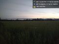
Road south of geohash @48.0184,-117.5072
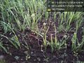
Cultivated @48.0184,-117.5072


Achievements