Difference between revisions of "2020-07-04 48 11"
From Geohashing
Clearlucid9 (talk | contribs) (→Expedition) |
|||
| Line 54: | Line 54: | ||
<!-- Add any achievement ribbons you earned below, or remove this section --> | <!-- Add any achievement ribbons you earned below, or remove this section --> | ||
| − | |||
| − | |||
| − | |||
| − | |||
| − | |||
| − | |||
| − | |||
| − | |||
| − | |||
| − | |||
| − | |||
| − | |||
| − | |||
| − | |||
[[Category:Expeditions]] | [[Category:Expeditions]] | ||
| − | |||
[[Category:Expeditions with photos]] | [[Category:Expeditions with photos]] | ||
| − | |||
| − | |||
| − | |||
| − | |||
| − | |||
[[Category:Coordinates reached]] | [[Category:Coordinates reached]] | ||
| − | |||
| − | |||
| − | |||
| − | |||
| − | |||
| − | |||
| − | |||
| − | |||
| − | |||
| − | |||
| − | |||
| − | |||
| − | |||
| − | |||
| − | |||
| − | |||
| − | |||
| − | |||
Revision as of 22:10, 4 July 2020
| Sat 4 Jul 2020 in 48,11: 48.0200255, 11.5078956 geohashing.info google osm bing/os kml crox |
Location
In a forrest south of Grünwald.
Participants
Plans
Expedition
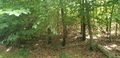
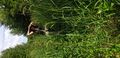
We were hoping to get out and take some fresh air this afternoon - so this hash that was located about 1 km walk from the carpark was a welcome target. There was quite a good forest trail up to 60m before the hash. From there we had to take an overgrown path with the grass about 1.7 m high and lots of thorns and stinging nettles. The last vie meters were blocked be young spruce trees, but putting on a summer jacket over the T-Shirt helped to make it through. Same way back afterwards and once out on the forest trail we had to pick the thorns from our trousers.
-- Clearlucid9 (talk) 20:30, 4 July 2020 (GMT+02:00)
Tracklog
Photos
Logproof

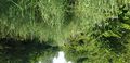
@hash
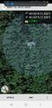
Surrounding
Way towards the hash
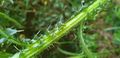
Thorns
Head high grass