2020-09-14 47 7
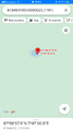
| Mon 14 Sep 2020 in 47,7: 47.9493122, 7.7918879 geohashing.info google osm bing/os kml crox |
Location
In a meadow on the Schönberg mountain, above Ebringen.
Participants
Expedition
With 112 km, this is my longest Bicycle geohash so far.
I started the journey by cycling to Marckolsheim and crossing the border. Then I took the direct route to Freiburg via the Kaiserstuhl hills, passed through Umkirch (which I had previously visited) and reached Ebringen in about 2 hours and a half.
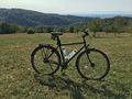
But I hadn't arrived at my destination yet. There still remained a 200 meters climb on the Schönberg mountain, which took me 30 long minutes and was quite exhausting as I hadn't eaten anything since I had left home. After leaving the road and pushing my bicycle on a rocky path, I finally reached a large meadow and the coordinates.
I headed back to Ebringen, stopped in the nearby town of Schallstadt to eat a big ice cream and have a drink, then cycled to Breisach, crossed the Rhine and returned home using the cycle track along the old Rhône–Rhine Canal.
Photos
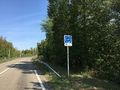
Crossing the border
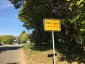
In Ebringen
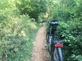
Almost there
The view to the geohash
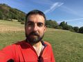
Stupid grin
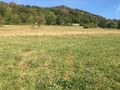
Coordinates reached
The view from the geohash


Achievements
Baarde earned the Land geohash achievement
|
Baarde earned the Bicycle geohash achievement
|
Baarde earned the Border geohash achievement
|
Baarde earned the Last man standing achievement
|