Difference between revisions of "2020-10-24 48 11"
Clearlucid9 (talk | contribs) (→Expedition) |
Clearlucid9 (talk | contribs) (→Tracklog) |
||
| Line 21: | Line 21: | ||
== Expedition == | == Expedition == | ||
I hadn't checked the hashpoints for the weekend ahead of time as I usually tend to do and was therefore supprised to find it "just around the corner" in the next village. After the rain we had earlier today had stopped and the sun started to come out I decided to drive & walk over. From the satellite pictures I knew I had to approach this one from behind or else I would have had to ask the owner of the houses there to grand me a right of way. Using the satellite image I found a more or less suitable path to get to the location that happend to be just 1m outside of the back garden fence. Taking my pictures and finding my way back to the car was the easy part. | I hadn't checked the hashpoints for the weekend ahead of time as I usually tend to do and was therefore supprised to find it "just around the corner" in the next village. After the rain we had earlier today had stopped and the sun started to come out I decided to drive & walk over. From the satellite pictures I knew I had to approach this one from behind or else I would have had to ask the owner of the houses there to grand me a right of way. Using the satellite image I found a more or less suitable path to get to the location that happend to be just 1m outside of the back garden fence. Taking my pictures and finding my way back to the car was the easy part. | ||
| − | |||
| − | |||
| − | |||
== Photos == | == Photos == | ||
Revision as of 15:16, 24 October 2020
| Sat 24 Oct 2020 in 48,11: 48.0491470, 11.6662382 geohashing.info google osm bing/os kml crox |
Location
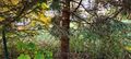
in a small strip of forest between Ottobrunn and Taufkirchen
Participants
Expedition
I hadn't checked the hashpoints for the weekend ahead of time as I usually tend to do and was therefore supprised to find it "just around the corner" in the next village. After the rain we had earlier today had stopped and the sun started to come out I decided to drive & walk over. From the satellite pictures I knew I had to approach this one from behind or else I would have had to ask the owner of the houses there to grand me a right of way. Using the satellite image I found a more or less suitable path to get to the location that happend to be just 1m outside of the back garden fence. Taking my pictures and finding my way back to the car was the easy part.
Photos

Very close

Right here, right now
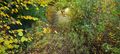
Overgrown footpath behind the gardens
Looking towards the houses
Achievements