Difference between revisions of "2021-01-17 44 -76"
From Geohashing
(... back in my day ...) |
|||
| (One intermediate revision by the same user not shown) | |||
| Line 6: | Line 6: | ||
== Location == | == Location == | ||
| − | |||
Public park in Kingston, ON. | Public park in Kingston, ON. | ||
| Line 16: | Line 15: | ||
Drive there, potentially with Dad. | Drive there, potentially with Dad. | ||
| − | [[Category: | + | == Expedition == |
| + | === [[User:SIGSTKFLT|SIGSTKFLT]] === | ||
| + | {{#vardefine:ribbontheme|mini}} | ||
| + | We drove there. With no cruise control because one of the wheel sensors is busted. | ||
| + | {{Land geohash|latitude=44|longitude=-76|date=2021-01-17}} | ||
| + | [[Category:Expeditions]] | ||
| + | [[Category:Expeditions with photos]] | ||
| + | [[Category:Coordinates reached]] | ||
| + | |||
| + | == Photos == | ||
| + | === [[User:SIGSTKFLT|SIGSTKFLT]] === | ||
| + | We drove there. | ||
| + | <gallery perrow="5"> | ||
| + | File:SIGSTKFLT 2021-01-17 44 -76 sig.jpg | SIG looking particularly stupid with their pants falling down. | ||
| + | SIGSTKFLT 2021-01-17 44 -76 dad.jpg | SIG's dad & the sign | ||
| + | </gallery> | ||
| + | |||
{{location|CA|ON|FR}} | {{location|CA|ON|FR}} | ||
Revision as of 22:36, 17 January 2021
| Sun 17 Jan 2021 in 44,-76: 44.2391942, -76.4983111 geohashing.info google osm bing/os kml crox |
Contents
Location
Public park in Kingston, ON.
Participants
Plans
SIGSTKFLT
Drive there, potentially with Dad.
Expedition
SIGSTKFLT
We drove there. With no cruise control because one of the wheel sensors is busted.
| Land geohash achievement by reaching the (44, -76) geohash on 2021-01-17. |
Photos
SIGSTKFLT
We drove there.
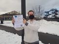
SIG looking particularly stupid with their pants falling down.
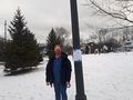
SIG's dad & the sign

