Difference between revisions of "2021-02-27 47 -52"
| (One intermediate revision by the same user not shown) | |||
| Line 12: | Line 12: | ||
[[User:Quiglax|Thomas]] | [[User:Quiglax|Thomas]] | ||
| − | + | Valeria | |
== Plans == | == Plans == | ||
| Line 22: | Line 22: | ||
[[File:opera_wQkSkVf0G9.jpg|400px|Planned Route]] | [[File:opera_wQkSkVf0G9.jpg|400px|Planned Route]] | ||
| − | + | Given the ongoing lockdown in our area due to the COVID-19 pandemic, my mother-in-law was feeling lonely and bored and decided to come along for the trip. After a two hour hike, we finally made it to the spot, which just happened to be atop of an embankment. Wasn't sure if we would be able to make it, but we persevered. Here are some photos from along the way and at the top. | |
| + | |||
| + | <gallery perrow="4"> | ||
| + | Image:Screenshot_20210227-124837.png | At the spot | ||
| + | Image:Screenshot_20210228-125451.png | Tracking profile | ||
| + | Image:PXL_20210227_154519180.jpg | A half built something, or a hunting encampment we came across | ||
| + | Image:PXL_20210227_161856332.MP.jpg | Me at the spot | ||
| + | Image:PXL_20210227_161941332.MP.jpg | Valeria making the final climb up the embankment | ||
| + | Image:PXL_20210227_162118376.MP.jpg | Us at the spot | ||
| + | Image:PXL_20210227_172621887.MP.jpg | Picture of the ocean washing up into a cave area with icicles from the cliff tops | ||
| + | </gallery> | ||
| + | |||
== Achievements == | == Achievements == | ||
[[Category:Expeditions]] | [[Category:Expeditions]] | ||
| − | Category:Expeditions with photos | + | [[Category:Expeditions with photos]] |
| − | Category:Coordinates reached | + | [[Category:Coordinates reached]] |
{{location|CA|NL|N}} | {{location|CA|NL|N}} | ||
Latest revision as of 16:39, 28 February 2021
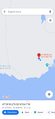
| Sat 27 Feb 2021 in 47,-52: 47.4750496, -52.6846505 geohashing.info google osm bing/os kml crox |
Location
Forested area along the coast near Maddox Cove. A few hundred meters off the East Coast Trail.
Participants
Valeria
Plans
The geohash is probably my most ambitious one to date. The East Coast Trail is a moderate hiking trail in some places at the best of times, but will now be snow covered. Snowshoes will be required to reach this geohash. Because of this, and the fact that it will be a 3+km round trip, I probably won't take the family; this will likely be a solo trip.
Expedition
Here is the planned route:

Given the ongoing lockdown in our area due to the COVID-19 pandemic, my mother-in-law was feeling lonely and bored and decided to come along for the trip. After a two hour hike, we finally made it to the spot, which just happened to be atop of an embankment. Wasn't sure if we would be able to make it, but we persevered. Here are some photos from along the way and at the top.
At the spot

Tracking profile
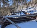
A half built something, or a hunting encampment we came across

Me at the spot
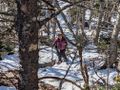
Valeria making the final climb up the embankment
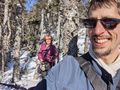
Us at the spot
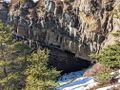
Picture of the ocean washing up into a cave area with icicles from the cliff tops


