Difference between revisions of "2021-04-16 38 -77"
m (Location) |
m |
||
| Line 21: | Line 21: | ||
Image: 4.16.21 Hashpoint.jpg|Proof | Image: 4.16.21 Hashpoint.jpg|Proof | ||
</gallery> | </gallery> | ||
| + | |||
| + | [[Category:Expeditions]] | ||
| + | [[Category:Expeditions with photos]] | ||
| + | [[Category:Coordinates reached]] | ||
{{location|US|DC}} | {{location|US|DC}} | ||
Latest revision as of 11:00, 24 September 2021
| Fri 16 Apr 2021 in 38,-77: 38.9082319, -77.0547336 geohashing.info google osm bing/os kml crox |
Contents
Location
Directly next to a basketball court near Rock Creek in the Georgetown neighborhood of Washington, DC.
Participants
Expedition
This hashpoint was a fun one. Living in an urban area, many of the hashpoints that land near me are on sidewalks, streets, or backyards. However, this one was in an urban recreational park near Rock Creek, a stream that runs through most of Northwest DC. Before heading to a friend's house for a campfire tonight, I swung by this hashpoint to grab a hash that looked to be pretty interesting and easy.
I parked on nearby 26th St, and walked towards the hash on the west side of a basketball court, where a pickup game was in full swing. I believe the precise point was directly on the sideline of the court, but not wanting to interfere in the game, I walked around the court to the south, where I was more easily able to reach the 10-meter circle around the hashpoint (which I count as reaching the point). The closest I reached to the hash was a few meters away, where I stood directly beneath an extraordinarily pink, flowering tree.
From this site, I took photos of the area. Unfortunately, I couldn't quite see down the valley to the stream, I only got a view of the nearby highway and the bike trail under construction. Nevertheless, it was an unusual hash, and allowed me to check out a park I hadn't gotten the chance to visit before.
From there, I went back to my car and on to my friend's house downtown.
Photos
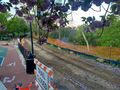
View from where I stood beneath the tree, overlooking the basketball court, bike trail under construction, and highway. I had hoped to see the river from here, but no luck.
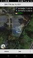
Proof

