Difference between revisions of "2021-07-12 48 8"
(→Location) |
m (Location) |
||
| (6 intermediate revisions by 2 users not shown) | |||
| Line 19: | Line 19: | ||
<!-- who attended: If you link to your wiki user name in this section, your expedition will be picked up by the various statistics generated for geohashing. You may use three tildes ~ as a shortcut to automatically insert the user signature of the account you are editing with. | <!-- who attended: If you link to your wiki user name in this section, your expedition will be picked up by the various statistics generated for geohashing. You may use three tildes ~ as a shortcut to automatically insert the user signature of the account you are editing with. | ||
--> | --> | ||
| − | [[User:Fenn|Fenn]] ([[User talk:Fenn|talk]]) | + | [[User:Fenn|Fenn]] ([[User talk:Fenn|talk]]) My first trip that I officially logged in the wiki |
== Plans == | == Plans == | ||
| Line 27: | Line 27: | ||
== Expedition == | == Expedition == | ||
<!-- how it all turned out. your narrative goes here. --> | <!-- how it all turned out. your narrative goes here. --> | ||
| − | Dumped the bike in the forest after the bridge and bee-lined towards the hut while looking out for fungi. Found some good ones! Got a bit lost but found the hut. Had lunch and left a chalk tag on the steps to the porch. At this point I wanted to turn on the GPS, but my phone was asking me for the PUK because the screen lock messed up in my pocket. Luckily after some cursing and removing the SIM card I got it running. Had to bushwhack my way through small, dense fir and made it to the spot. | + | Dumped the bike in the forest after the bridge and bee-lined towards the hut while looking out for fungi. Found some good ones! Got a bit lost but found the hut. Had lunch and left a chalk tag on the steps to the porch. At this point I wanted to turn on the GPS, but my phone was asking me for the PUK because the screen lock messed up in my pocket. Luckily after some cursing and removing the SIM card I got it running. Had to bushwhack my way through small, dense patch of fir wood and made it to the spot. |
== Tracklog == | == Tracklog == | ||
| Line 38: | Line 38: | ||
Image:2020-##-## ## ## Alpha.jpg | Witty Comment | Image:2020-##-## ## ## Alpha.jpg | Witty Comment | ||
--> | --> | ||
| − | |||
<gallery perrow="5"> | <gallery perrow="5"> | ||
| − | Image: | + | Image:2021-07-12 48 8 bridge.jpg | Had to carry the bike up the stairs over this stream |
Image:2021-07-12 48 8 hut.jpg | The hut was locked | Image:2021-07-12 48 8 hut.jpg | The hut was locked | ||
Image:2021-07-12 48 8 fungi.jpg | Never found this many good mushrooms | Image:2021-07-12 48 8 fungi.jpg | Never found this many good mushrooms | ||
</gallery> | </gallery> | ||
| − | |||
| − | |||
| − | |||
| − | |||
| − | |||
| − | |||
| − | |||
| − | |||
| − | |||
| − | |||
| − | |||
| − | |||
| − | |||
| − | |||
| − | |||
| − | |||
[[Category:Expeditions]] | [[Category:Expeditions]] | ||
| − | |||
[[Category:Expeditions with photos]] | [[Category:Expeditions with photos]] | ||
| − | |||
| − | |||
| − | |||
| − | |||
| − | |||
[[Category:Coordinates reached]] | [[Category:Coordinates reached]] | ||
| − | + | {{location|DE|BW|CW}} | |
| − | |||
| − | |||
| − | |||
| − | |||
| − | |||
| − | |||
| − | |||
| − | |||
| − | |||
| − | |||
| − | |||
| − | |||
| − | |||
| − | |||
| − | |||
| − | |||
| − | |||
Latest revision as of 10:42, 15 July 2021
| Mon 12 Jul 2021 in 48,8: 48.5348734, 8.6251929 geohashing.info google osm bing/os kml crox |
Location
Dense forest between Beihingen and Bösingen with a wooden hut nearby
Participants
Fenn (talk) My first trip that I officially logged in the wiki
Plans
Cross the Waldach stream via the small footbridge, then head up towards the hut and scout for an access path that's not covered by shrubs.
Expedition
Dumped the bike in the forest after the bridge and bee-lined towards the hut while looking out for fungi. Found some good ones! Got a bit lost but found the hut. Had lunch and left a chalk tag on the steps to the porch. At this point I wanted to turn on the GPS, but my phone was asking me for the PUK because the screen lock messed up in my pocket. Luckily after some cursing and removing the SIM card I got it running. Had to bushwhack my way through small, dense patch of fir wood and made it to the spot.
Tracklog
 Low battery and the removed SIM card
Photos
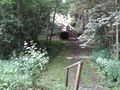
Had to carry the bike up the stairs over this stream
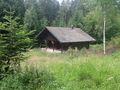
The hut was locked
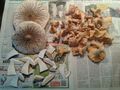
Never found this many good mushrooms


