Difference between revisions of "2021-07-16 40 -4"
(Created page with "<!-- [[Image:{{{image|IMAGE}}}|thumb|left]] --> <!-- Remove this section if you don't want an image at the top (left) of your report. You should remove the "Image...") |
m (looks finished, removing Category: New report) |
||
| Line 90: | Line 90: | ||
<!-- Add any achievement ribbons you earned below, or remove | <!-- Add any achievement ribbons you earned below, or remove | ||
this section --> | this section --> | ||
| − | |||
| − | |||
| − | |||
| − | |||
| − | |||
| − | |||
| − | |||
<!-- An actual expedition: --> | <!-- An actual expedition: --> | ||
Revision as of 06:55, 20 July 2021
| Fri 16 Jul 2021 in 40,-4: 40.4989362, -4.1982577 geohashing.info google osm bing/os kml crox |
Location
In the wilds, near the road between Fresnedillas de la Oliva and Robledo de Chavela.
Participants
Plans
Expedition
Having done a couple of expeditions in my area, a pattern begins to emerge due to two facts:
- Outside of the big cities, central Spain is sparsely populated.
- Spain has a well developed road network.
Consequently,
- the geohash is usually in the wilds,
- there is usually a road that takes you within reasonable walking distance to the geohash.
There remain two questions:
- Is there a fence?
- Is there parking space next to the road?
Traveling on a motorcycle, the latter may not deem critical, but often there's the ditch directly next to the road and no parking space, certainly not for my larger and heavier motorcycles.
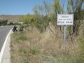
This day during lunch break, I had to go to the post office in the center of Valdemorillo. The parking situation is usually a bit tense there, so the smaller the vehicle, the better. Therefore, I took my little Krähe. On the way back home, I took a diversion to go for the geohash.
Fortunately, I could park die Krähe next to the road directly at the point closest to the geohash. It was only 200 meters from the road as the crow flies, but the terrain was a bit challenging, with large boulders and dense bushes. A couple of times, I had to go back and try another path. Finally, I reached the geohash on a picturesque wild meadow, surrounded by boulders and bushes. I took some photos and went back home, arriving just in time to resume work.
Tracklog
Photos
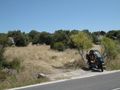
Convenient parking for the little Krähe.
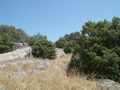
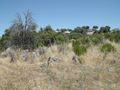
On into the wilds.
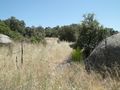
Someone (not me) had pushed the fence down to step over it — I accepted the invitation.
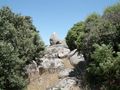
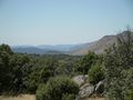
The effort to climb up the boulders…
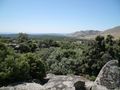
… is rewarded by the view.
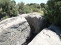
The direction to the geohash. The depth of the crevice is worrying me, so I go back and look for another route.
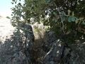
Here I can squeeze myself through…
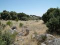
… and directly behind is the meadow where the geohash lives.
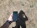
Proof.
It's where I put the dead branch in the ground.
On the way back, I had a (distant) view of the 70 meters antenna of NASA's Madrid Deep Space Communications Complex. Unfortunately, I didn't take my photo case with the tele lens with me on this walk.
Bye bye.


