2021-09-06 48 8
| Mon 6 Sep 2021 in 48,8: 48.8779560, 8.4178172 geohashing.info google osm bing/os kml crox |
Location
On a foresttrail near Burbach
Participants
Expedition
This was another fun one. We were on our way home from a holiday in the south of Germany and of course looking for reachable hashes along it. The chosen location was near to our intended path and also was a perfect excuse to visit the beautiful black forest on our way there. We had originally intended to hike around the hash location in the Alb valley since the available online photos of it where simply gorgeous. But we noticed that the recommended trail was more than 40 km long and weren't able to easily identify where exactly along it the pictures where from.
While searching around Santu suddenly came across something else on the maps and excitedly shouted "Uhhhhh we have to go there!". It was the "Treetop Walk Black Forest" which was also along the way and relatively near to the hash location. So we went there and started exploring the area. And there was much to see!
On top of the "summer hill" are several venues including a suspension bridge, an off-road bike trail and an adventure playground. But we chose to only go along the Treetop Walk with a 40 m high lookout tower at its end. We had a lot of fun there in the brilliant sunny weather and Gefrierbrands fear of falling (not fear of heights) was manageable so we both were able to go completely to the top.
We then continued through narrow windy roads towards the hash location. It was relatively easy to find right next to a medium-sized road. Since we were unsure where to park we stopped a few hundred meters away from it at the beginning of a small forest path which was not really visible on the satellite images. But it enabled us to go parallel to the road without having to walk into traffic. Moreover, we where able to reach the hashlocation right from there.
So we took the obligatory pictures and then wandered around a bit to at least have a look at the Alb. We found a weir with a walkway over it and intended to cross it, but unfortunately it was closed off. We therefore continued without further exploring the creek, which is now left for future adventures.
Photos
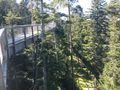
walkway in the treetops
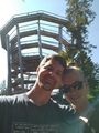
grinning in front of the lookout tower
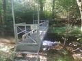
closed bridge over a weir
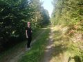
Santu at the Hash

stupid grinTM
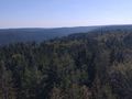
view from the tower towards the suspension bridge
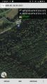
proof


Achievements
Santu & Gefrierbrand earned the Land geohash achievement
|
Gefrierbrand achieved level 4 of the Minesweeper Geohash achievement
|
Santu achieved level 5 of the Minesweeper Geohash achievement
|
