2021-09-08 49 8
| Wed 8 Sep 2021 in 49,8: 49.9177060, 8.1162573 geohashing.info google osm bing/os kml crox |
Location
In a field, just outside Stadecken-Elsheim
Participants
Expedition
Looking at the coordinates, I was excited to see that it was very close to my home, being only about 7km from the edge of Mainz. It's a pretty straight-forward route, and I had even already been to the destination village Stadecken-Elsheim, so I roughly knew where to go.
My route began at the entrance of the Ober-Olmer Forst, which provided nice shading against the bright sunshine my expedition was blessed with. The weather was very pleasant overall, neither too hot to cycle up a hill nor to cool to pass through a forest, complemented by a clear blue sky.
Having left the forest and the following village Essenheim behind, my previous knowledge paid off due to the path proposed by OSM being blocked because of roadwork. I was forced to leave the paved way in favor of the bordering vineyards. Cycling a grassy agricultural road uphill proved more exhausting than I had expected, so I took a break at the apex, where I also took a photo of the nice view atop the hill.
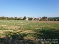
From there on it was a fun downhill ride to reach Stadecken-Elsheim, where I used the public roads for the last bit to the destination, just outside the village in a field, about 20m away from the pathway.
Photos
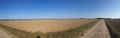
A panorama taken between Ober-Olmer Forst and Essenheim
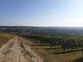
Atop the hill nr.1 ...
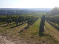
... and 2 (lower angle due to sun)
Proof!
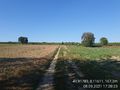
Path to the destination
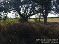
Look toward destination
My bike!
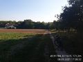
Fourth direction
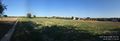
Panorama view of the destination

Standing in front of the destination with messy hair, thanks helmet...


Achievements
Tarek earned the Land geohash achievement
|
Tarek earned the Bicycle geohash achievement
|
