2021-09-17 40 -4
| Fri 17 Sep 2021 in 40,-4: 40.3052358, -4.5194771 geohashing.info google osm bing/os kml crox |
Location
Inaccessible, on a huge fenced property near Rozas de Puerto Real.
Participants
Plans
Expedition
I post this report late, and I was not even sure if I should post it at all. I did not reach the coordinates and I don't have anything particularly interesting to tell or any particularly nice photo to show. Nevertheless, for completeness, here it is.
It had been raining the last few days, but this Friday it was back to normal mode, nice and sunny. The geohash was relatively close, a three quaters of an hour motorcycle ride, and only about 300 meters from a road. So I was thinking I could easily make it leaving (home) office at a quater past five and being back home well before dark.
However, I had to find out that the geohash was located on a huge property that was protected by quite a substantial fence. From where I could park the motorcycle, it was 600 meters as the crow flies. I chose to walk to the right along the fence as on the Maps it had looked like there were some paths leading close to the geohash. But the paths I had seen must have been on the other side of the fence, which never ended. I walked along until I was 2 km from the geohash, and still no end of the fence in sight.
At this point I gave up. I took a photo in the direction towards the geohash, where a pronounced hill was visible, and walked the about one and a half kilometers back to the bike. There, I checked again direction, and it pointed to the very same hill. Therefore, the geohash could not have been far from the top of the hill. Even without fence, it might have been difficult to reach it.
I rode back home and made it just before dark. At least this went according to plan.
Tracklog
Photos
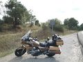
Convenient parking for the old Goldwing by the side of the road.
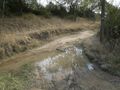
Remnants of the rain in the last few days.
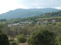
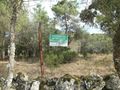
A settlement nested nicely in the hills.
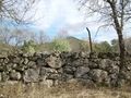
This does not look easy to squeeze through.
And it does not get better over one and a half kilometers along the fence.
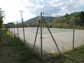
A tennis court in the middle of nowhere — I was thinking, however, the march along the fence had taken me close to the settlement I had seen from a distance earlier.
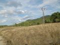
At this point I give up. The geohash is 2 km away in viewing direction, note the hill in the center. The fence is obscured by the grass covered wall in the front.
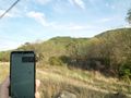
Back at the parking place, it is 600 meters away in viewing direction. Note the very same hill. The geohash must be close to the top.


