2021-09-19 48 7
| Sun 19 Sep 2021 in 48,7: 48.1906191, 7.4397067 geohashing.info google osm bing/os kml crox |
Location
In a field near Illhaeusern
Participants
Plans
I'm a little bit tired after yesterday's expedition, the weather is meh, and it's probably yet another cornfield. But it's very close, so I guess I'll attempt it.
Expedition
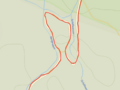
I left home at 14:20 and headed toward Illhaeusern. The most direct route from Sélestat to Illhaeusern is a foot path that goes through the Illwald forest then runs along an arm of the river Ill. It did not look very bicycleable, and until today I had always picked the longer route, which follows the EuroVelo 5 next to the vineyards between Kintzheim and Bergheim. But Geohashing is a game of spontaneous adventure…
As expected, the path wasn't great: mostly grass and dirt, with a lot of potholes, a couple of sections of cobblestones and some strange meanders. It's not terrible, but in the future I'll probably stick to nicer route.
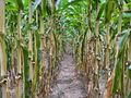
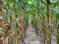
As I approached the village, the forest and the meadows gave way to a sea of corn. As I had feared, the geohash was yet again in a cornfield. However, this time, there was a direct path from the path to the hashpoint between two rows of cornstalks.
Photos
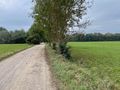
Illwald forest
Why?!
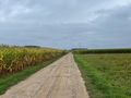
Is it gonna be yet another cornfield?
Yes, it is.
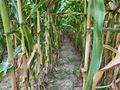
But there is an access!
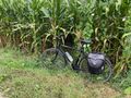
Coordinates reached
Surroundings (West)
Surroundings (East)
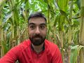
Stupid grin


Achievements
Baarde earned the Land geohash achievement
|
Baarde earned the Bicycle geohash achievement
|
Baarde earned the Consecutive geohash achievement
|