Difference between revisions of "2021-09-26 49 8"
Gefrierbrand (talk | contribs) ([live picture]proof) |
Gefrierbrand (talk | contribs) |
||
| (14 intermediate revisions by 3 users not shown) | |||
| Line 1: | Line 1: | ||
| − | + | {{meetup graticule | |
| − | |||
| − | |||
| − | |||
| − | |||
| − | |||
| − | |||
| − | |||
| − | |||
| lat=49 | | lat=49 | ||
| lon=8 | | lon=8 | ||
| date=2021-09-26 | | date=2021-09-26 | ||
| − | }} | + | }} |
__NOTOC__ | __NOTOC__ | ||
== Location == | == Location == | ||
| − | + | On the Edge of a field next to the Autobahn near Mörfelden | |
== Participants == | == Participants == | ||
| − | + | *[[User:Santu|Santu]] | |
| − | + | *[[User:Gefrierbrand|Gefrierbrand]] | |
| + | *Pedro the dog | ||
| − | == | + | == Expedition == |
| − | + | On this day, Pedro was taking part in a dog race (obviously for the fun of it, not to win any prizes). We had already registered him but had time to kill until his starting slot. So we decided to go on a little geohashing adventure to a nearby hash. Getting there was easy, but finding a parkingspace was not. We had scouted the map for potential spots and found quite a few, but each and every location was either already occupied or parking was explicitly forbidden. | |
| − | + | This meant we had to backtrack and approach from a different angle, but was not a huge deal. We managed to find a place about 1,5 km from the location and started walking towards it. Along the way we passed a little lake with lots of people around camping and fishing, and quite a few actually swimming in it despite the already cooling weather. | |
| − | + | ||
| + | We quickly reached the hash-containing field but were abruptly stopped by an electric fence. Luckily, a quick glance on the map revealed another possible approach angle which was only a small detour. It meant going along the water a bit further. The lakeshore is an official nudists-beach (called [https://en.wikipedia.org/wiki/Freik%C3%B6rperkultur FKK] in Germany) so we obviously did not take too many pictures there. | ||
| + | |||
| + | Coming back to the big field from the other side, we noticed huge powerlines above our heads which were strangely buzzing and fizzing due to the moisture in the air and on them. The hash was right next to them so we only had to follow them, which was slightly spooky due to the noises coming from them. | ||
| + | |||
| + | While walking towards our goal, we suddenly noticed a flock of sheep only a few dozen meters away from us with no fence or any other restriction between us. So we made sure that Pedro did not notice them and continued quickly. We then reached the hash, took the necessary pictures and tried to get away from the sheep again without disturbing them, which worked well. They completely ignored us the whole time. | ||
| − | + | We were wondering if we'd missed a broken fence or accidentally wandered on a closed field, but could not find any signs or barriers or something like that, so perhaps sheep simply don't move around that much an can be kept on open fields. But we did not ponder long because we had to focus on Pedros race next ;) | |
| − | |||
== Photos == | == Photos == | ||
| − | |||
| − | |||
| − | |||
<gallery perrow="5"> | <gallery perrow="5"> | ||
| − | + | Image:2021-09-26_49_8_Gefrierbrand_1632663249652.jpg|stones | |
| + | Image:2021-09-26_49_8_Gefrierbrand_1632663238540.jpg|lake | ||
| + | Image:2021-09-26_49_8_Gefrierbrand_1632663215682.jpg|fence | ||
| + | Image:2021-09-26_49_8_Gefrierbrand_1632722364508.jpg|flowers | ||
| + | Image:2021-09-26_49_8_Gefrierbrand_1632722396865.jpg|walk | ||
| + | Image:2021-09-26_49_8_Gefrierbrand_1632663189758.jpg|sheep | ||
| + | Image:2021-09-26_49_8_Gefrierbrand_1632722379972.jpg|StupidGrin<sup>TM</sup> | ||
| + | Image:2021-09-26 49 8 pedro.JPG|Pedro running | ||
Image:2021-09-26_49_8_Gefrierbrand_1632663155788.jpg|proof | Image:2021-09-26_49_8_Gefrierbrand_1632663155788.jpg|proof | ||
</gallery> | </gallery> | ||
| Line 40: | Line 41: | ||
== Achievements == | == Achievements == | ||
{{#vardefine:ribbonwidth|800px}} | {{#vardefine:ribbonwidth|800px}} | ||
| − | + | {{land geohash | |
| + | | latitude = 49 | ||
| + | | longitude = 8 | ||
| + | | date = 2021-09-26 | ||
| + | | name = Santu & Gefrierbrand | ||
| + | }} | ||
| − | |||
| − | |||
| − | |||
| − | |||
| − | |||
| − | |||
| − | |||
| − | |||
| − | |||
| − | |||
| − | |||
| − | |||
| − | |||
| − | |||
[[Category:Expeditions]] | [[Category:Expeditions]] | ||
| − | |||
[[Category:Expeditions with photos]] | [[Category:Expeditions with photos]] | ||
| − | |||
| − | |||
| − | |||
| − | |||
| − | |||
[[Category:Coordinates reached]] | [[Category:Coordinates reached]] | ||
| − | + | [[Category:Expeditions with dogs]] | |
| − | + | {{location|DE|HE|GG}} | |
| − | |||
| − | |||
| − | |||
| − | |||
| − | |||
| − | |||
| − | |||
| − | |||
| − | |||
| − | |||
| − | [[Category: | ||
| − | |||
| − | |||
| − | |||
| − | |||
| − | |||
Latest revision as of 07:57, 18 October 2022
| Sun 26 Sep 2021 in 49,8: 49.9669009, 8.6034972 geohashing.info google osm bing/os kml crox |
Location
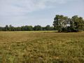
On the Edge of a field next to the Autobahn near Mörfelden
Participants
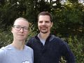
- Santu
- Gefrierbrand
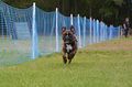
- Pedro the dog
Expedition
On this day, Pedro was taking part in a dog race (obviously for the fun of it, not to win any prizes). We had already registered him but had time to kill until his starting slot. So we decided to go on a little geohashing adventure to a nearby hash. Getting there was easy, but finding a parkingspace was not. We had scouted the map for potential spots and found quite a few, but each and every location was either already occupied or parking was explicitly forbidden.
This meant we had to backtrack and approach from a different angle, but was not a huge deal. We managed to find a place about 1,5 km from the location and started walking towards it. Along the way we passed a little lake with lots of people around camping and fishing, and quite a few actually swimming in it despite the already cooling weather.
We quickly reached the hash-containing field but were abruptly stopped by an electric fence. Luckily, a quick glance on the map revealed another possible approach angle which was only a small detour. It meant going along the water a bit further. The lakeshore is an official nudists-beach (called FKK in Germany) so we obviously did not take too many pictures there.
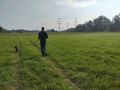
Coming back to the big field from the other side, we noticed huge powerlines above our heads which were strangely buzzing and fizzing due to the moisture in the air and on them. The hash was right next to them so we only had to follow them, which was slightly spooky due to the noises coming from them.
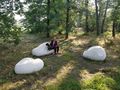
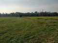
While walking towards our goal, we suddenly noticed a flock of sheep only a few dozen meters away from us with no fence or any other restriction between us. So we made sure that Pedro did not notice them and continued quickly. We then reached the hash, took the necessary pictures and tried to get away from the sheep again without disturbing them, which worked well. They completely ignored us the whole time.
We were wondering if we'd missed a broken fence or accidentally wandered on a closed field, but could not find any signs or barriers or something like that, so perhaps sheep simply don't move around that much an can be kept on open fields. But we did not ponder long because we had to focus on Pedros race next ;)
Photos
stones
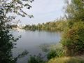
lake
fence
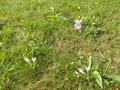
flowers
walk
sheep
StupidGrinTM
Pedro running
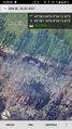
proof


Achievements
Santu & Gefrierbrand earned the Land geohash achievement
|