Difference between revisions of "2021-09-29 54 37"
(Created page with "{{subst:Expedition}}") |
|||
| Line 1: | Line 1: | ||
| − | + | {{meetup graticule | |
| − | |||
| − | |||
| − | |||
| − | |||
| − | |||
| − | |||
| − | |||
| − | |||
| lat={{#explode:{{SUBPAGENAME}}| |1}} | | lat={{#explode:{{SUBPAGENAME}}| |1}} | ||
| lon={{#explode:{{SUBPAGENAME}}| |2}} | | lon={{#explode:{{SUBPAGENAME}}| |2}} | ||
| date={{#explode:{{SUBPAGENAME}}| |0}} | | date={{#explode:{{SUBPAGENAME}}| |0}} | ||
| − | }} | + | }} |
__NOTOC__ | __NOTOC__ | ||
== Location == | == Location == | ||
| − | + | On the road in Zalugi (lit. beyond the grass plains) village. | |
== Participants == | == Participants == | ||
| − | + | * [[User:V1993|V1993]] ([[User talk:V1993|talk]]) | |
| − | |||
== Plans == | == Plans == | ||
| − | + | After checking out tomorrow's hashes I've noticed one in Zalugi, about 1km away from Pochinki. Since there's a plenty of buses between Stupino and Pochinki, I've decided to attend it. | |
== Expedition == | == Expedition == | ||
| − | + | I've caught a bus to Pochinki earlier than expected. Got OSMAnd open, added a waypoint near destination not to miss it, and sat back, watching terrain as well as OSMAnd map go by. After a while I've noticed that I was approaching Pochinki stop despite there still being about 10km from waypoint and quickly realized what went wrong: there are just more than one Pochinki around here! | |
| − | + | Having realized this, I got off the bus and, after snapping a couple of pictures, got on a bus to home. Also checked if it was feasible to get to the "right" Pochinki, but sadly it was not. | |
| − | |||
== Photos == | == Photos == | ||
| Line 34: | Line 24: | ||
--> | --> | ||
<gallery perrow="5"> | <gallery perrow="5"> | ||
| + | Image:2021-09-29 54 37 phone 1.png | They got a public phone there, huh | ||
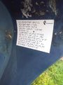
| + | Image:2021-09-29 54 37 phone 2.png | It's even operational! | ||
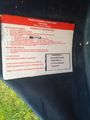
| + | Image:2021-09-29 54 37 phone 3.png | And also have description for the blind | ||
| + | Image:2021-09-29 54 37 phone timetable.png | Proof that I was in (the wrong) Pochinki | ||
</gallery> | </gallery> | ||
== Achievements == | == Achievements == | ||
{{#vardefine:ribbonwidth|800px}} | {{#vardefine:ribbonwidth|800px}} | ||
| − | + | {{gratuitous ribbon | |
| + | | color = red | ||
| + | | icon = No the other one.png | ||
| + | | latitude = 54 | ||
| + | | longitude = 37 | ||
| + | | date = 2021-09-29 | ||
| + | | achievement = No, The Other One Consolation Prize | ||
| + | | description = failing to reach the hash because of arrived into wrong village Pochinki, 10km away from intended one | ||
| + | | name = [[User:V1993|V1993]] | ||
| + | }} | ||
| − | |||
| − | |||
| − | |||
| − | |||
| − | |||
| − | |||
| − | |||
| − | |||
| − | |||
| − | |||
| − | |||
| − | |||
| − | |||
[[Category:Expeditions]] | [[Category:Expeditions]] | ||
| − | |||
[[Category:Expeditions with photos]] | [[Category:Expeditions with photos]] | ||
| − | |||
| − | |||
| − | |||
| − | |||
| − | |||
| − | |||
| − | |||
| − | |||
| − | |||
[[Category:Coordinates not reached]] | [[Category:Coordinates not reached]] | ||
| − | |||
| − | |||
| − | |||
| − | |||
| − | |||
| − | |||
| − | |||
| − | |||
| − | |||
| − | |||
| − | |||
| − | |||
| − | |||
| − | |||
Revision as of 12:08, 30 September 2021
| Wed 29 Sep 2021 in 54,37: 54.9793103, 37.7985895 geohashing.info google osm bing/os kml crox |
Location
On the road in Zalugi (lit. beyond the grass plains) village.
Participants
Plans
After checking out tomorrow's hashes I've noticed one in Zalugi, about 1km away from Pochinki. Since there's a plenty of buses between Stupino and Pochinki, I've decided to attend it.
Expedition
I've caught a bus to Pochinki earlier than expected. Got OSMAnd open, added a waypoint near destination not to miss it, and sat back, watching terrain as well as OSMAnd map go by. After a while I've noticed that I was approaching Pochinki stop despite there still being about 10km from waypoint and quickly realized what went wrong: there are just more than one Pochinki around here!
Having realized this, I got off the bus and, after snapping a couple of pictures, got on a bus to home. Also checked if it was feasible to get to the "right" Pochinki, but sadly it was not.
Photos
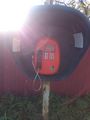
They got a public phone there, huh
It's even operational!
And also have description for the blind
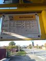
Proof that I was in (the wrong) Pochinki


Achievements
V1993 earned the No, The Other One Consolation Prize
|