Difference between revisions of "2021-10-12 51 7"
(An expedition message sent via Geohash Droid for Android.) |
m (Location) |
||
| (8 intermediate revisions by 2 users not shown) | |||
| Line 1: | Line 1: | ||
| − | + | {{meetup graticule | |
| − | |||
| − | |||
| − | |||
| − | |||
| − | |||
| − | |||
| − | |||
| − | |||
| lat=51 | | lat=51 | ||
| lon=7 | | lon=7 | ||
| Line 15: | Line 7: | ||
== Location == | == Location == | ||
<!-- where you've surveyed the hash to be --> | <!-- where you've surveyed the hash to be --> | ||
| + | The hash was on the terrain of a ruined building that was secured with a fence. | ||
== Participants == | == Participants == | ||
<!-- who attended: If you link to your wiki user name in this section, your expedition will be picked up by the various statistics generated for geohashing. You may use three tildes ~ as a shortcut to automatically insert the user signature of the account you are editing with. | <!-- who attended: If you link to your wiki user name in this section, your expedition will be picked up by the various statistics generated for geohashing. You may use three tildes ~ as a shortcut to automatically insert the user signature of the account you are editing with. | ||
--> | --> | ||
| + | *[[User:Tanka|Tanka]] | ||
| + | *[[User:GeorgDerReisende|GeorgDerReisende]] | ||
== Plans == | == Plans == | ||
<!-- what were the original plans --> | <!-- what were the original plans --> | ||
| + | ===GeorgDerReisende=== | ||
| + | As usual: a journey with trams, trains and buses. And a walk. | ||
== Expedition == | == Expedition == | ||
| + | ===Tanka=== | ||
<!-- how it all turned out. your narrative goes here. --> | <!-- how it all turned out. your narrative goes here. --> | ||
| + | This was my first hash today. I went there by train and then walked just 100 meters. I was there by pure coincidence at the right time to meet another Geohasher ([[User:GeorgDerReisende|GeorgDerReisende]]). | ||
| + | The area on which the hash was located was unfortunately a ruined building that was secured with a fence. However, I got within 36 meters. Not a bad start for the beginning. | ||
| + | ===GeorgDerReisende=== | ||
| + | I left Kassel at 11 o'clock. With one train I traveled to Dortmund-Hörde. There I changed to the underground. During the whole journey it was raining. But with my arriving at Dortmund the rain stopped. I walked through the quarter near the hash and then to the hash. And I found the whole property devastated and overgrown. I walked around the block and looked for an entrance to the area but I didn't find any. Disappointed I walked back to the entrance to document my failure. While doing the documentation a guy walked to me and asked me: „Are you a geohasher?“ And I met Tanka. He told me he just discovered the game the day before, he lives only some kilometers away and today it was his first try. What a success! | ||
== Tracklog == | == Tracklog == | ||
<!-- if your GPS device keeps a log, you may use Template:Tracklog, post a link here, or both --> | <!-- if your GPS device keeps a log, you may use Template:Tracklog, post a link here, or both --> | ||
| Line 33: | Line 35: | ||
Image:2020-##-## ## ## Alpha.jpg | Witty Comment | Image:2020-##-## ## ## Alpha.jpg | Witty Comment | ||
--> | --> | ||
| + | ===Tanka=== | ||
<gallery perrow="5"> | <gallery perrow="5"> | ||
| + | |||
| + | Image:2021-10-12_51_7_Tanka_1634068632268.jpg|I got within 36 meters. Not a bad start for the beginning. [https://openstreetmap.org/?mlat=51.50300000&mlon=7.51500000&zoom=16 @51.5030,7.5150] | ||
| + | </gallery> | ||
| + | ===GeorgDerReisende=== | ||
| + | <gallery> | ||
| + | File:2021-10-12 51 7 GeorgDerReisende Screenshot_20211013_013513.jpg | planning view, airial view | ||
| + | File:2021-10-12 51 7 GeorgDerReisende Screenshot_20211013_013939.jpg | planning view, from the street | ||
| + | File:2021-10-12 51 7 GeorgDerReisende 9116.jpg | first view: a fence | ||
| + | File:2021-10-12 51 7 GeorgDerReisende 9120.jpg | second view: always the fence | ||
| + | File:2021-10-12 51 7 GeorgDerReisende 9124.jpg | overgrown company sign | ||
| + | File:2021-10-12 51 7 GeorgDerReisende 9125.jpg | abandoned building | ||
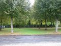
| + | File:2021-10-12 51 7 GeorgDerReisende 9130.jpg | interesting view from the north | ||
| + | File:2021-10-12 51 7 GeorgDerReisende 9135.jpg | another abandoned property on the block | ||
| + | File:2021-10-12 51 7 GeorgDerReisende 9138.jpg | residential street on the eastern side | ||
| + | File:2021-10-12 51 7 GeorgDerReisende 9140.jpg | the third abandoned area on the block | ||
| + | File:2021-10-12 51 7 GeorgDerReisende 9142.jpg | proof from the south | ||
| + | File:2021-10-12 51 7 GeorgDerReisende 9143.jpg | looking from the south | ||
| + | File:2021-10-12 51 7 GeorgDerReisende 9147.jpg | somewhere there | ||
| + | File:2021-10-12 51 7 GeorgDerReisende 9149.jpg | GeorgDerReisende and Tanka | ||
| + | File:2021-10-12 51 7 GeorgDerReisende 9151.jpg | my best shot | ||
</gallery> | </gallery> | ||
| Line 40: | Line 63: | ||
<!-- Add any achievement ribbons you earned below, or remove this section --> | <!-- Add any achievement ribbons you earned below, or remove this section --> | ||
| − | + | {{meetup | latitude = 51 | longitude = 7 | date = 2021-10-12 | name = [[User:GeorgDerReisende|GeorgDerReisende]] and [[User:Tanka|Tanka]] | other = each other }} | |
| − | |||
| − | [[ | ||
| − | + | [[Category:Expeditions]] | |
| − | |||
| − | |||
| − | |||
| − | [[Category: | ||
| − | |||
| − | |||
| − | |||
| − | |||
| − | |||
| − | |||
[[Category:Expeditions with photos]] | [[Category:Expeditions with photos]] | ||
| − | |||
| − | |||
| − | |||
| − | |||
| − | |||
| − | |||
| + | [[Category:Coordinates not reached]] | ||
| − | |||
| − | |||
| − | |||
| − | |||
| − | |||
| − | |||
| − | |||
[[Category:Not reached - No public access]] | [[Category:Not reached - No public access]] | ||
| − | + | {{location|DE|NW|DO}} | |
| − | |||
| − | |||
| − | |||
| − | |||
| − | |||
| − | |||
| − | |||
Latest revision as of 00:42, 13 October 2021
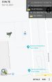
| Tue 12 Oct 2021 in 51,7: 51.5029646, 7.5156728 geohashing.info google osm bing/os kml crox |
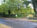
Location
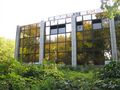
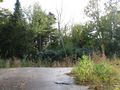
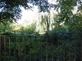
The hash was on the terrain of a ruined building that was secured with a fence.
Participants
Plans
GeorgDerReisende
As usual: a journey with trams, trains and buses. And a walk.
Expedition
Tanka
This was my first hash today. I went there by train and then walked just 100 meters. I was there by pure coincidence at the right time to meet another Geohasher (GeorgDerReisende). The area on which the hash was located was unfortunately a ruined building that was secured with a fence. However, I got within 36 meters. Not a bad start for the beginning.
GeorgDerReisende
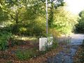
I left Kassel at 11 o'clock. With one train I traveled to Dortmund-Hörde. There I changed to the underground. During the whole journey it was raining. But with my arriving at Dortmund the rain stopped. I walked through the quarter near the hash and then to the hash. And I found the whole property devastated and overgrown. I walked around the block and looked for an entrance to the area but I didn't find any. Disappointed I walked back to the entrance to document my failure. While doing the documentation a guy walked to me and asked me: „Are you a geohasher?“ And I met Tanka. He told me he just discovered the game the day before, he lives only some kilometers away and today it was his first try. What a success!
Tracklog
Photos
Tanka
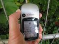
I got within 36 meters. Not a bad start for the beginning. @51.5030,7.5150

GeorgDerReisende
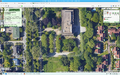
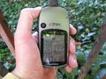
planning view, airial view
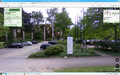
planning view, from the street
first view: a fence
second view: always the fence
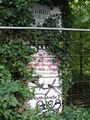
overgrown company sign
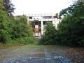
abandoned building
interesting view from the north
another abandoned property on the block
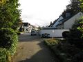
residential street on the eastern side
the third abandoned area on the block
proof from the south
looking from the south
somewhere there
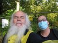
GeorgDerReisende and Tanka
my best shot


Achievements
GeorgDerReisende and Tanka earned the Meet-up achievement
|