Difference between revisions of "2022-01-08 33 -117"
From Geohashing
(→Tracklog) |
m (Location) |
||
| (4 intermediate revisions by 2 users not shown) | |||
| Line 1: | Line 1: | ||
| − | <!-- If you did not specify these parameters in the template, please substitute appropriate values for IMAGE, LAT, LON, and DATE (YYYY-MM-DD format) | + | {{Advert | image = 2022-01-08_33_-117_Bravissimo594_1641698347889.jpg }} |
| + | <!-- If you did not specify these parameters in the template, please substitute appropriate values for IMAGE, LAT, LON, and DATE (YYYY-MM-DD format) --> | ||
| − | [[Image:{{{image| | + | [[Image:{{{image|2022-01-08_33_-117_Bravissimo594_1641698292046.jpg}}}|thumb|left]] |
| − | Remove this section if you don't want an image at the top (left) of your report. You should remove the "Image:" or "File:" | + | <!-- Remove this section if you don't want an image at the top (left) of your report. You should remove the "Image:" or "File:" |
tag from your image file name, and replace the all upper-case word IMAGE in the above line. | tag from your image file name, and replace the all upper-case word IMAGE in the above line. | ||
| Line 24: | Line 25: | ||
== Plans == | == Plans == | ||
<!-- what were the original plans --> | <!-- what were the original plans --> | ||
| − | [[User:Bravissimo594|Bravissimo594]] ([[User talk:Bravissimo594|talk]]) plans to visit this Chevron parking lot sometime between 7:30 pm and 8:00 pm local time. As early as 7:00 pm might even be possible. | + | * [[User:Bravissimo594|Bravissimo594]] ([[User talk:Bravissimo594|talk]]) plans to visit this Chevron parking lot sometime between 7:30 pm and 8:00 pm local time. As early as 7:00 pm might even be possible. |
| − | * Wayz puts ETA at 7:10 pm local time. [[User:Bravissimo594|Bravissimo594]] ([[User talk:Bravissimo594|talk]] | + | ** Wayz puts ETA at 7:10 pm local time (UTC-0800). – [[User:Bravissimo594|Bravissimo594]] ([[User talk:Bravissimo594|talk]]) |
== Expedition == | == Expedition == | ||
<!-- how it all turned out. your narrative goes here. --> | <!-- how it all turned out. your narrative goes here. --> | ||
| − | I had an all-day trip scheduled to Laguna Niguel, California, and this hashpoint looked both accessible and not far off of my route home. The maps all were correct, and I was able to make it to the spot at a Chevron station at about 7:15 pm local time ( | + | I had an all-day trip scheduled to Laguna Niguel, California, and this hashpoint looked both accessible and not far off of my route home. The maps all were correct, and I was able to make it to the spot at a Chevron station at about 7:15 pm local time (UTC-0800), took a few photos, and then headed home. Success! -- [[User:Bravissimo594|Bravissimo594]] ([[User talk:Bravissimo594|talk]]) |
<!-- == Tracklog == --> | <!-- == Tracklog == --> | ||
| Line 53: | Line 54: | ||
<!-- Add any achievement ribbons you earned below, or remove this section --> | <!-- Add any achievement ribbons you earned below, or remove this section --> | ||
| − | |||
| − | |||
| − | |||
| − | |||
| − | |||
| − | |||
| − | |||
| − | |||
| − | |||
| − | |||
| − | |||
| − | |||
| − | |||
| − | |||
[[Category:Expeditions]] | [[Category:Expeditions]] | ||
| − | |||
[[Category:Expeditions with photos]] | [[Category:Expeditions with photos]] | ||
| − | |||
| − | |||
[[Category:Coordinates reached]] | [[Category:Coordinates reached]] | ||
| − | + | {{location|US|CA|OR}} | |
| − | |||
| − | |||
| − | |||
| − | |||
| − | |||
| − | |||
| − | |||
| − | |||
| − | |||
| − | |||
| − | |||
| − | |||
| − | |||
| − | |||
| − | |||
| − | |||
| − | |||
Latest revision as of 09:43, 28 January 2022
| Have you seen our geohashing marker? We'd love to hear from you! Click here to say "hi" and tell us what you've seen!
Curious about what geohashing is? Read more! |  |

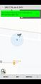
| Sat 8 Jan 2022 in 33,-117: 33.6796599, -117.8860768 geohashing.info google osm bing/os kml crox |
Location
Outside of a Chevron station in Costa Mesa.
Participants
Plans
- Bravissimo594 (talk) plans to visit this Chevron parking lot sometime between 7:30 pm and 8:00 pm local time. As early as 7:00 pm might even be possible.
- Wayz puts ETA at 7:10 pm local time (UTC-0800). – Bravissimo594 (talk)
Expedition
I had an all-day trip scheduled to Laguna Niguel, California, and this hashpoint looked both accessible and not far off of my route home. The maps all were correct, and I was able to make it to the spot at a Chevron station at about 7:15 pm local time (UTC-0800), took a few photos, and then headed home. Success! -- Bravissimo594 (talk)
Photos
Made it!
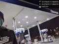
Standing on the spot. @33.6796,-117.8860
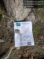
Left a marker nearby (off of the concrete). @33.6796,-117.8860
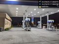
View of the day's per-gallon prices. @33.6796,-117.8860

