2022-02-06 41 -81
| Sun 6 Feb 2022 in 41,-81: 41.3886040, -81.3483988 geohashing.info google osm bing/os kml crox |
Location
Just off US 422 in Bainbridge, Ohio
Participants
Expedition
Late write-up so I don't remember all the details, but J took me to Cleveland for my birthday weekend. Unfortunately, there was nothing on the way or during our stay, but this one looked potentially reachable and was sort-of on the way home.
After checking out of our hotel, we stopped for brunch at a nice restaurant south of the city (but I don't remember where exactly). We then headed to the Cuyahoga Valley National Park which looked immense and had a lot of trails. It seems that this is broken up into smaller parks and we ended up in the Brecksville Park area. We saw a Nature Center on the map so we stopped there to get some advice on what trails we should hike. It was a bit crazy because they were giving away handfuls of birdseed to hand feed the Chickadees and other birds, so understandably, I didn't get to talk to a ranger for very long so we just looked at the trail-map and found about a 4-5 mile(~7 KM) loop. Plus, it said there was a cave to check out (Deer Lick Cave). Parking near the cave area, we headed in and it turned out to just be an eroded indentation in the rock a handful of meters deep (horizontally). It was frozen, so we were able to walk under the overhang, but we didn't hang around long.
We ended up seeing a couple groups on the main trail, but after we took the shortcut in the middle to the other side of the park (basically cut the main loop in half), we didn't see anyone until we were almost back at the car. It was a perfect day for a winter hike.
We then took a detour toward the Geohash before heading for home. I gave J my phone set to the HashDroid app so she could grab a screenshot as we drove by, and she was also going to take some pictures on her phone too for the surroundings. About an exit away from the Geohash, I started regulating my speed so I wouldn't be driving near a group of other cars, because the plan was to drift onto the shoulder of the road as we went by to get a few extra feet closer. Approaching the spot, I set the speedometer for a Speed Racer and told J to get ready. I kind of pointed out the guardrail ahead I saw on the map that was closest to the hashpoint and said it would be close to the end of that. It was clear, so I was able to move halfway onto the shoulder lane before coming back. J got very quiet as we got to the exit right after the hash and when I looked over, she had a weird look on her face. I asked her what was wrong and it turned out she accidentally turned off my phone. Getting it back on, it didn't have time to relocate itself and we missed the hash. She was very upset she 'ruined everything and we have to do that again'. I was ok with just heading for home and calling it a terrible run in with Technology, but she was adamant. So we got back on US 422, turned around at the next exit and made another run. I think our proof wasn't as good the second time, as there were more cars around me so I didn't go as far onto the shoulder, but you can see we should still have been able to catch the edge of the Circle of Uncertainty for a successful run.
Due to the shenanigans, I totally forgot to get a screenshot of the weather, but it was definitely a Frozen Hash too (You can see in the Cave picture from earlier, the non-shiny ice which shows it wasn't melting at all at the time). Also, because J was controlling the phones, I don't recall if she took a picture of our speed or not for the Speed Racer.
Photos
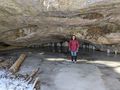
Deer Lick 'Cave' on our hike.
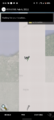
Disaster!
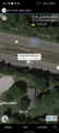
Backtracking to try again...
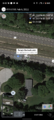
Better this time. First Screenshot just before the hash...
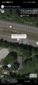
And just after we passed it.


Ribbons
This user earned the Land geohash achievement
|

