Difference between revisions of "2022-02-08 51 -1"
(→Expedition) |
m (Location) |
||
| (3 intermediate revisions by 2 users not shown) | |||
| Line 1: | Line 1: | ||
| + | {{User:DanQ/Template:DanQBlog | url = https://danq.me/2022/02/08/geohashing-expedition-2022-02-08-51-1/}} | ||
{{meetup graticule | {{meetup graticule | ||
|lat=51 | |lat=51 | ||
| Line 21: | Line 22: | ||
== Expedition == | == Expedition == | ||
Made a quick run out here by car, as I was travelling nearby on an errand anyway. Had to be a flying visit because my partner needed the car after me! | Made a quick run out here by car, as I was travelling nearby on an errand anyway. Had to be a flying visit because my partner needed the car after me! | ||
| + | |||
| + | Was able to pull into a layby within 60 metres of the hashpoint. It was at the edge of the field, just on the other side of the hedge, but a gap in the hedge allowed me to pop through for a quick selfie. | ||
== Tracklog == | == Tracklog == | ||
| − | + | {{ tracklog | Track_2022-02-08 51 -1 HASH.gpx }} | |
| + | (only outbound leg shown, as after this I went elsewhere before circling back home) | ||
== Photos == | == Photos == | ||
| − | < | + | <gallery perrow='2'> |
| − | Image: | + | Image:20220208_114213.jpg | Zero point |
| − | + | Image:20220208_114231.jpg | Silly grin | |
| − | |||
</gallery> | </gallery> | ||
| − | |||
| − | |||
| − | |||
| − | |||
| − | |||
| − | |||
| − | |||
| − | |||
| − | |||
| − | |||
| − | |||
| − | |||
[[Category:Expeditions]] | [[Category:Expeditions]] | ||
| − | |||
[[Category:Expeditions with photos]] | [[Category:Expeditions with photos]] | ||
| − | |||
| − | |||
| − | |||
| − | |||
| − | |||
[[Category:Coordinates reached]] | [[Category:Coordinates reached]] | ||
| − | + | {{location|GB|ENG|OXF}} | |
| − | |||
| − | |||
| − | |||
| − | |||
| − | |||
| − | |||
| − | |||
| − | |||
| − | |||
| − | |||
| − | |||
| − | |||
| − | |||
| − | |||
| − | |||
| − | |||
| − | |||
Latest revision as of 13:42, 16 February 2022
|
Dan Q also wrote about this expedition on his blog. For more details and higher-resolution pictures, see this expedition's log at https://danq.me/2022/02/08/geohashing-expedition-2022-02-08-51-1/ |
| Tue 8 Feb 2022 in 51,-1: 51.6885877, -1.4189051 geohashing.info google osm bing/os kml crox |
Location
Edge of a field, Kingston Bagpuize.
(Bagpuize is pronounced /ˈbæɡpjuːz/, by the way: bag-pyooz.)
Participants
Plans
This looks eminently achievable: it's about half an hour's cycle from my house: in fact one of my favourite evening cycle routes normally takes me to the nearby junction of the A415 and Appleton Road before I go the other direction along it, up the hill to Appleton then on to Cumnor. I've never been this way down Appleton Road.
At a glance, it looks like the hashpoint is alongside the road, over a dyke. Street level photography makes it look like it'll be possible to jump over, and the hashpoint is probably on the "public highway" side of the tree line rather than in the field itself.
The challenge will be timing. My Tuesdays are hectic as I juggle work in the mornings and evenings with childcare in the afternoons. If I can get far enough ahead of my work (e.g. starting early on Tuesday) I can probably justify the cycle as part of my lunch break. Alternatively, I could come down for a spot of night-hashing after the children are in bed. It's hard to commit to which time is best, but as I'm likely to be the only hasher there I don't think I need to refine my plans any more than that at this point!
Expedition
Made a quick run out here by car, as I was travelling nearby on an errand anyway. Had to be a flying visit because my partner needed the car after me!
Was able to pull into a layby within 60 metres of the hashpoint. It was at the edge of the field, just on the other side of the hedge, but a gap in the hedge allowed me to pop through for a quick selfie.
Tracklog
(only outbound leg shown, as after this I went elsewhere before circling back home)
Photos
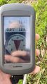
Zero point

Silly grin

