Difference between revisions of "2022-05-09 -37 145"
From Geohashing
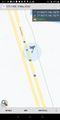
([live picture]5 [https://openstreetmap.org/?mlat=-37.95175000&mlon=145.10176944&zoom=16 @-37.9518,145.1018]) |
|||
| Line 14: | Line 14: | ||
__NOTOC__ | __NOTOC__ | ||
== Location == | == Location == | ||
| − | + | In a ditch between the Dingley Bypass and a bike path. | |
== Participants == | == Participants == | ||
| − | + | * [[User:Stevage|Stevage]] | |
| − | + | * [[User:MDixon4|MDixon4]] | |
| − | + | * [[User:Lachie|Lachie]] | |
== Plans == | == Plans == | ||
<!-- what were the original plans --> | <!-- what were the original plans --> | ||
| Line 66: | Line 66: | ||
[[Category:New report]] | [[Category:New report]] | ||
| − | |||
| − | |||
| − | |||
| − | |||
| − | |||
| − | |||
| − | |||
| − | |||
| − | |||
| − | |||
[[Category:Expeditions]] | [[Category:Expeditions]] | ||
| − | |||
[[Category:Expeditions with photos]] | [[Category:Expeditions with photos]] | ||
| − | |||
| − | |||
| − | |||
| − | |||
| − | |||
[[Category:Coordinates reached]] | [[Category:Coordinates reached]] | ||
| − | |||
| − | |||
| − | |||
| − | |||
| − | |||
| − | |||
| − | |||
| − | |||
| − | |||
| − | |||
| − | |||
| − | |||
| − | |||
| − | |||
| − | |||
| − | |||
| − | |||
| − | |||
Revision as of 05:24, 9 May 2022
| Mon 9 May 2022 in -37,145: -37.9518558, 145.1017192 geohashing.info google osm bing/os kml crox |
Location
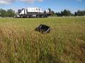
In a ditch between the Dingley Bypass and a bike path.
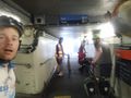
Participants
Plans
Expedition
Tracklog
Photos
GPS Proof
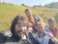
Couch hash!
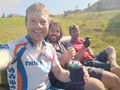
Hash beers!
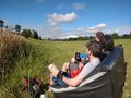
Admiring the view
Our couch at the hash
The departure


