Difference between revisions of "2022-05-12 51 9"
(Created page with "{{meetup graticule|date=2022-05-12|lat=51|lon=9}} ==Location== In a forest north east of Dörnhagen ==Participants== *Digiphono ==Plans== I'm planning to...") |
|||
| (One intermediate revision by the same user not shown) | |||
| Line 1: | Line 1: | ||
| − | {{meetup graticule|date=2022-05-12 | + | {{meetup graticule |
| − | ==Location== | + | | lat=51 |
| + | | lon=9 | ||
| + | | date=2022-05-12 | ||
| + | }} | ||
| + | |||
| + | <!-- edit as necessary --> | ||
| + | __NOTOC__ | ||
| + | |||
| + | == Location == | ||
In a forest north east of Dörnhagen | In a forest north east of Dörnhagen | ||
| − | ==Participants== | + | == Participants == |
| − | + | [[User:Digiphono|Digiphono]] | |
| + | |||
| + | == Plans == | ||
| + | <!-- what were the original plans --> | ||
| + | After work, I will drive to Dörnhagen and do a nice walk to the hash. I'll be there around 2:45 pm I guess... | ||
| + | |||
| + | == Expedition == | ||
| + | <!-- how it all turned out. your narrative goes here --> | ||
| + | As planned, I drove to and through Dörnhagen and parked my car at the 'Schwarzer Markt' Wanderparkplatz and went for a nice walk on the so called Energieweg Söhre (which means something like Energypath Söhre, the latter part being the name for the wooded area east of Kassel, the Söhrewald). This is a 5 kilometer path which leads along 5 huge wind turbines (140 meters in height) and having information about climate change, renewable energy etc. at each of the 5 stations. Those stations were part of a so called Adventure Lab Cache, where one has to answer a question at each station, to find one geocache at the end of the tour (as a bonus so to say)... So, today I combined two hobbys, starting with the geohash, which happened to be only 250 meters from the parking lot... | ||
| + | |||
| + | I walked some 180 meters on a gravel path and had to go straight into the forest for the final 70 meters. The vegetation was quite rampant but still it was easy to find a way through the thorny bushes and after a little hash dance I located the hash as being an old tree trunk. Made some pics for proof and then returned to get back on the path and did the 5 km tour subsequently... | ||
| + | |||
| + | At the end, I also managed to find the geocache so the day was quite ok for me! | ||
| − | == | + | == Photos == |
| − | + | <gallery> | |
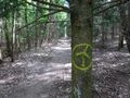
| + | Image:2022-05-12_51_9_001.jpg|On my way to the hash | ||
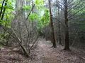
| + | Image:2022-05-12_51_9_002.jpg|The last 70 meters... | ||
| + | Image:2022-05-12_51_9_003.jpg|...to the hash | ||
| + | Image:2022-05-12_51_9_004.jpg|The hasher at the has location | ||
| + | Image:2022-05-12_51_9_005.jpg|Huge wind turbine nearby | ||
| + | Image:2022-05-12_51_9_006.jpg|The energy path | ||
| + | Image:2022-05-12_51_9_007.jpg|Great atmosphere | ||
| + | Image:2022-05-12_51_9_008.jpg|Proof | ||
| + | </gallery> | ||
| − | [[Category: | + | [[Category:Expeditions]] |
| + | [[Category:Expeditions with photos]] | ||
| + | [[Category:Coordinates reached]] | ||
{{location|DE|HE|KS}} | {{location|DE|HE|KS}} | ||
Latest revision as of 16:45, 12 May 2022
| Thu 12 May 2022 in 51,9: 51.2453924, 9.5161617 geohashing.info google osm bing/os kml crox |
Location
In a forest north east of Dörnhagen
Participants
Plans
After work, I will drive to Dörnhagen and do a nice walk to the hash. I'll be there around 2:45 pm I guess...
Expedition
As planned, I drove to and through Dörnhagen and parked my car at the 'Schwarzer Markt' Wanderparkplatz and went for a nice walk on the so called Energieweg Söhre (which means something like Energypath Söhre, the latter part being the name for the wooded area east of Kassel, the Söhrewald). This is a 5 kilometer path which leads along 5 huge wind turbines (140 meters in height) and having information about climate change, renewable energy etc. at each of the 5 stations. Those stations were part of a so called Adventure Lab Cache, where one has to answer a question at each station, to find one geocache at the end of the tour (as a bonus so to say)... So, today I combined two hobbys, starting with the geohash, which happened to be only 250 meters from the parking lot...
I walked some 180 meters on a gravel path and had to go straight into the forest for the final 70 meters. The vegetation was quite rampant but still it was easy to find a way through the thorny bushes and after a little hash dance I located the hash as being an old tree trunk. Made some pics for proof and then returned to get back on the path and did the 5 km tour subsequently...
At the end, I also managed to find the geocache so the day was quite ok for me!
Photos
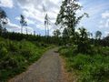
On my way to the hash
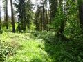
The last 70 meters...
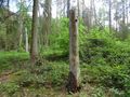
...to the hash

The hasher at the has location
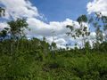
Huge wind turbine nearby
The energy path
Great atmosphere

Proof


