Difference between revisions of "2022-06-03 50 7"
Gefrierbrand (talk | contribs) ([retro picture]gefrierbrand climbing) |
Gefrierbrand (talk | contribs) |
||
| Line 1: | Line 1: | ||
| − | + | {{meetup graticule | |
| − | |||
| − | |||
| − | |||
| − | |||
| − | |||
| − | |||
| − | |||
| − | |||
| lat=50 | | lat=50 | ||
| lon=7 | | lon=7 | ||
| − | | date=2022- | + | | date=2022-05-02 |
| − | }} | + | }} |
__NOTOC__ | __NOTOC__ | ||
| − | == Location == | + | ==Location== |
| − | + | On a very steep slope in the woods near Alken | |
| − | + | == Expedition == | |
| − | == | + | For this Geohashing adventure, we returned to Castle Thurant which we visited [[2021-01-17 50 7|last year]]. Only this time the hash was actually close to it. It was (again) located on a very steep slope and at first we considered stopping the adventure only 30 m away from our goal. But fortunately Santu was able to spot a "path" downhill and ventured along carefully with Gefrierbrand following her shortly. |
| − | |||
| − | |||
| − | + | As it turned out, this wasn't a path at all, and the ground was loose and on more than one occasion, several small stones have come loose from under our feet and rolled down the slope. This could not stop us (literally) and we more or less stumbled towards the hashlocation while holding on to old and sometimes rotten trees and branches. | |
| − | |||
| − | + | We quickly took the necessary proof and a silly photo before trying to get back to more stable terrain. Climbing uphill was significantly more difficult than getting down and Gefrierbrand only managed to get back with a helping hand from Santu. In the end all went well and we continued to the castle. | |
| − | |||
| − | + | This year it was opened and we quickly glanced inside before continuing on our way. Perhaps we'll visit it again on another geohashing Adventure. | |
| − | |||
== Photos == | == Photos == | ||
| − | |||
| − | |||
| − | |||
<gallery perrow="5"> | <gallery perrow="5"> | ||
| − | + | Image:2022-06-03_50_7_Gefrierbrand_1654355407230.jpg|Castle Thurant from afar | |
| − | Image:2022-06-03_50_7_Gefrierbrand_1654355374810.jpg|castle | + | Image:2022-06-03_50_7_Gefrierbrand_1654355374810.jpg|inside the castle |
| − | + | Image:2022-06-03_50_7_Gefrierbrand_1654355430238.jpg|Santu climbing | |
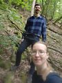
| − | Image:2022-06- | + | Image:2022-06-03_50_7_Gefrierbrand_1654355542241.jpg|Gefrierbrand climbing |
| − | + | Image:2022-06-03_50_7_Gefrierbrand_1654355526758.jpg|StupidGrin<sup>TM</sup> | |
| − | Image:2022-06- | ||
| − | |||
Image:2022-06-03_50_7_Gefrierbrand_1654355512576.jpg|proof | Image:2022-06-03_50_7_Gefrierbrand_1654355512576.jpg|proof | ||
| − | |||
| − | |||
| − | |||
| − | |||
</gallery> | </gallery> | ||
== Achievements == | == Achievements == | ||
| − | {{ | + | {{land geohash |
| − | + | | latitude = 50 | |
| + | | longitude = 7 | ||
| + | | date = 2022-06-03 | ||
| + | | name = Gefrierbrand & Sanut | ||
| + | }} | ||
| − | |||
| − | |||
| − | |||
| − | |||
| − | |||
| − | |||
| − | |||
| − | |||
| − | |||
| − | |||
| − | |||
| − | |||
| − | |||
[[Category:Expeditions]] | [[Category:Expeditions]] | ||
| − | |||
[[Category:Expeditions with photos]] | [[Category:Expeditions with photos]] | ||
| − | |||
| − | |||
| − | |||
| − | |||
| − | |||
[[Category:Coordinates reached]] | [[Category:Coordinates reached]] | ||
| − | |||
| − | |||
| − | |||
| − | |||
| − | |||
| − | |||
| − | |||
| − | |||
| − | |||
| − | |||
| − | |||
| − | |||
| − | |||
| − | |||
| − | |||
| − | |||
| − | |||
| − | |||
Revision as of 15:27, 4 June 2022
| Mon 2 May 2022 in 50,7: 50.0152025, 7.4929489 geohashing.info google osm bing/os kml crox |
Location
On a very steep slope in the woods near Alken
Expedition
For this Geohashing adventure, we returned to Castle Thurant which we visited last year. Only this time the hash was actually close to it. It was (again) located on a very steep slope and at first we considered stopping the adventure only 30 m away from our goal. But fortunately Santu was able to spot a "path" downhill and ventured along carefully with Gefrierbrand following her shortly.
As it turned out, this wasn't a path at all, and the ground was loose and on more than one occasion, several small stones have come loose from under our feet and rolled down the slope. This could not stop us (literally) and we more or less stumbled towards the hashlocation while holding on to old and sometimes rotten trees and branches.
We quickly took the necessary proof and a silly photo before trying to get back to more stable terrain. Climbing uphill was significantly more difficult than getting down and Gefrierbrand only managed to get back with a helping hand from Santu. In the end all went well and we continued to the castle.
This year it was opened and we quickly glanced inside before continuing on our way. Perhaps we'll visit it again on another geohashing Adventure.
Photos
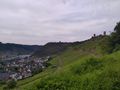
Castle Thurant from afar
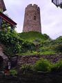
inside the castle
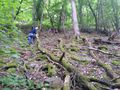
Santu climbing
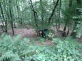
Gefrierbrand climbing
StupidGrinTM

proof


Achievements
Gefrierbrand & Sanut earned the Land geohash achievement
|