Difference between revisions of "2022-06-28 57 -2"
Macronencer (talk | contribs) m (→Tracklog: Add tracklog for walking section) |
m (Location) |
||
| (2 intermediate revisions by one other user not shown) | |||
| Line 52: | Line 52: | ||
--> | --> | ||
<gallery perrow="5"> | <gallery perrow="5"> | ||
| + | Image:2022-06-28 57 -2 Macronencer 01 terrain.png | Overview of the terrain | ||
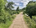
| + | Image:2022-06-28 57 -2 Macronencer 02 access-path.jpg | Access path to site | ||
| + | Image:2022-06-28 57 -2 Macronencer 03 bridge.jpg | Bridge over a wee burn | ||
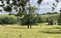
| + | Image:2022-06-28 57 -2 Macronencer 04 river-plain.jpg | River plain | ||
| + | Image:2022-06-28 57 -2 Macronencer 05 bench.jpg | Bench | ||
| + | Image:2022-06-28 57 -2 Macronencer 06 old-tree.jpg | Old Tree | ||
| + | Image:2022-06-28 57 -2 Macronencer 07 castle-boundary.jpg | The Castle Boundary Wall | ||
| + | Image:2022-06-28 57 -2 Macronencer 08 castle-and-cows.jpg | Castle - with orcs. Er, I mean cattle. | ||
| + | Image:2022-06-28 57 -2 Macronencer 09 foxglove.jpg | Foxglove | ||
| + | Image:2022-06-28 57 -2 Macronencer 10 nice-tree.jpg | Nicely shaped tree | ||
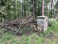
| + | Image:2022-06-28 57 -2 Macronencer 11 cnr-face.jpg | CNR face :( | ||
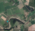
| + | Image:2022-06-28 57 -2 Macronencer 12 overview-of-cnr-distance.png | Overview of CNR position relative to hash. About 700m away! | ||
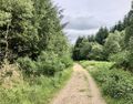
| + | Image:2022-06-28 57 -2 Macronencer 13 walking-track.jpg | Walking track (see also Tracklog above) | ||
</gallery> | </gallery> | ||
| Line 57: | Line 70: | ||
{{#vardefine:ribbonwidth|800px}} | {{#vardefine:ribbonwidth|800px}} | ||
<!-- Add any achievement ribbons you earned below, or remove this section --> | <!-- Add any achievement ribbons you earned below, or remove this section --> | ||
| + | {{Hashiversary | ||
| + | | new=2022-06-28 57 -2 | ||
| + | | original=2009-06-28 50 -1 | ||
| + | | ordinal=13th | ||
| + | | name=[[User:Macronencer|Macronencer]] | ||
| + | | gender=his | ||
| + | }} | ||
<!-- =============== USEFUL CATEGORIES FOLLOW ================ | <!-- =============== USEFUL CATEGORIES FOLLOW ================ | ||
Delete the next line ONLY if you have chosen the appropriate categories below. If you are unsure, don't worry. People will read your report and help you with the classification. --> | Delete the next line ONLY if you have chosen the appropriate categories below. If you are unsure, don't worry. People will read your report and help you with the classification. --> | ||
| − | |||
<!-- ==REQUEST FOR TWITTER BOT== Please leave either the New report or the Expedition planning category in as long as you work on it. This helps the twitter bot a lot with announcing the right outcome at the right moment. --> | <!-- ==REQUEST FOR TWITTER BOT== Please leave either the New report or the Expedition planning category in as long as you work on it. This helps the twitter bot a lot with announcing the right outcome at the right moment. --> | ||
| − | |||
| − | |||
| − | |||
| − | |||
| − | |||
[[Category:Expeditions]] | [[Category:Expeditions]] | ||
| Line 73: | Line 87: | ||
[[Category:Not reached - Mother Nature]] | [[Category:Not reached - Mother Nature]] | ||
[[Category:Not reached - No public access]] | [[Category:Not reached - No public access]] | ||
| − | |||
| − | |||
| − | |||
[[Category:Expeditions with photos]] | [[Category:Expeditions with photos]] | ||
| − | + | {{location|GB|SCT|ABD}} | |
| − | |||
| − | |||
| − | |||
| − | |||
| − | |||
| − | |||
| − | |||
| − | |||
| − | |||
| − | |||
| − | |||
| − | |||
| − | |||
| − | |||
| − | |||
| − | |||
| − | |||
| − | |||
| − | |||
| − | |||
| − | |||
| − | |||
| − | |||
Latest revision as of 12:42, 29 June 2022
| Tue 28 Jun 2022 in 57,-2: 57.4399662, -2.3046283 geohashing.info google osm bing/os kml crox |
Location
Close to a footpath in the Gight Woods nature reserve.
Participants
Plans
This is fairly close to me so looks worth a shot this evening!
Expedition
Macronencer’s journey
When I looked at this location I was taken by surprise. I’ve lived in Aberdeenshire for seven months now, and had no idea that one of the few remaining pieces of ancient woodland in the county lay just a few miles away from me. It looked idyllic in the photographs, so I planned a trip. I was especially pleased that this was happening on my Hashiversary date, 13 years after my first geohash (wow, it’s been a while!). I didn’t yet have a Hashiversary achievement, so that was nice. The access looked OK to me at the time: the hash was near a path that led from a bridge over the river.
After work, I checked the weather. It looked as if it would get worse in an hour or two, so I thought I’d better go immediately. I drove to the public car park, and had a nice walk down through woods and over a little bridge (not the bridge mentioned above, though). I was wearing wellies… which probably wasn’t the best idea, but my walking boots still have mildew on them and I need to clean them up. I’d underestimated the distances involved, and wellies hurt my toes when I walk downhill – probably because I have very long toes. Very long toes would be great if I could swing from trees or something, but that particular superpower seems to have eluded me.
I reached a gate, and spotted cattle in the field around Gight Castle. I didn’t see any calves, but I thought I should give them a wide berth so as not to worry them. As a result, I never went near the river.
At the end of the area of grassland there was a fence, and a few gates that led only into jungle territory with impassable vegetation. Looking at the Ordnance Survey maps, I do believe at least one of those gates was supposed to be for the public footpath – but the state of the undergrowth was too much for me as I had no machete (or bulldozer).
Checking the weather app, I saw that rain was due in about twenty minutes, and I had things to do at home. Reluctantly, I decided to abort the trip and log a CNR.
In hindsight, I might have been able to cross the river if I’d gone farther out of my way by turning left when I got near the river so that I could backtrack to where there seems to be a bridge. I’m going to have to come back and check one day, to see whether I could have reached the co-ordinates after all with more time! I’ll certainly be bringing my camera if I do that, as the place is really beautiful and I’m keen to try and get a photo of something interesting (such as a red squirrel).
Tracklog
Photos
Overview of the terrain
Access path to site
Bridge over a wee burn
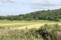
River plain
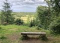
Bench
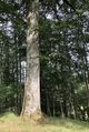
Old Tree
The Castle Boundary Wall
Castle - with orcs. Er, I mean cattle.
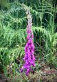
Foxglove
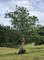
Nicely shaped tree

CNR face :(
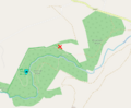
Overview of CNR position relative to hash. About 700m away!
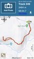
Walking track (see also Tracklog above)


Achievements
Macronencer earned the 13th Hashiversary achievement
|