Difference between revisions of "2022-06-29 52 4"
FelixTheCat (talk | contribs) (Created page with "{{subst:Expedition |lat = 52 |lon = 4 |date = 2022-06-29 }}") |
FelixTheCat (talk | contribs) |
||
| Line 1: | Line 1: | ||
| − | + | {{meetup graticule | |
| − | |||
| − | |||
| − | |||
| − | |||
| − | |||
| − | |||
| − | |||
| − | |||
| lat=52 | | lat=52 | ||
| lon=4 | | lon=4 | ||
| date=2022-06-29 | | date=2022-06-29 | ||
| − | }} | + | }} |
__NOTOC__ | __NOTOC__ | ||
== Location == | == Location == | ||
| − | + | Bitterzoetpad, Ypenburg, The Hague Municipality. | |
== Participants == | == Participants == | ||
| − | + | [[User:FelixTheCat|FelixTheCat]] ([[User talk:FelixTheCat|talk]]) | |
| − | |||
| − | |||
| − | |||
| − | |||
== Expedition == | == Expedition == | ||
| − | + | Today's hash was in a lucky location: on a bike path less than 2 km from my workplace. I cycled there after work, found the point without any problem, took the required pictures and went home again. An easy hash on a beautiful summer's day. | |
| − | |||
| − | |||
| − | |||
== Photos == | == Photos == | ||
| − | |||
| − | |||
| − | |||
<gallery perrow="5"> | <gallery perrow="5"> | ||
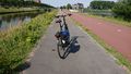
| + | Image:2022-06-29 52 4 FelixTheCat 1.JPG | The Rijswijkse Landingslaan, the main road through the Ypenburg area. The hash is right ahead. | ||
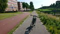
| + | Image:2022-06-29 52 4 FelixTheCat 2.JPG | My bike parked exactly on the spot, just beside the bike path. | ||
| + | Image:2022-06-29 52 4 FelixTheCat 3.png | GPS proof. | ||
| + | Image:2022-06-29 52 4 FelixTheCat 4.JPG | Lloyd celebrating. | ||
| + | Image:2022-06-29 52 4 FelixTheCat 5.JPG | Looking to the northeast. Ypenburg used to be an airfield, but it was closed in the early '90s and converted into a residential area. The main road through it (where we're standing now) used to be the runway. | ||
| + | Image:2022-06-29 52 4 FelixTheCat 6.JPG | Looking southwest. | ||
| + | Image:2022-06-29 52 4 FelixTheCat 7.JPG | These Egyptian geese (''Alopochen aegyptiaca'') were making a lot of noise when I arrived, and were curious to know what this visitor was doing on their territory. | ||
</gallery> | </gallery> | ||
== Achievements == | == Achievements == | ||
{{#vardefine:ribbonwidth|800px}} | {{#vardefine:ribbonwidth|800px}} | ||
| − | + | {{bicycle geohash | |
| − | + | | latitude = 52 | |
| − | + | | longitude = 4 | |
| − | + | | date = 2022-06-29 | |
| − | [[ | + | | name = [[User:FelixTheCat|FelixTheCat]] ([[User talk:FelixTheCat|talk]]) |
| − | + | | distance = 1.9 km | |
| − | + | | bothways = false | |
| − | + | }} | |
| − | |||
| − | |||
| − | [[ | ||
| − | |||
| − | |||
| − | |||
| − | |||
| − | |||
[[Category:Expeditions]] | [[Category:Expeditions]] | ||
| − | |||
[[Category:Expeditions with photos]] | [[Category:Expeditions with photos]] | ||
| − | |||
| − | |||
| − | |||
| − | |||
| − | |||
[[Category:Coordinates reached]] | [[Category:Coordinates reached]] | ||
| − | |||
| − | |||
| − | |||
| − | |||
| − | |||
| − | |||
| − | |||
| − | |||
| − | |||
| − | |||
| − | |||
| − | |||
| − | |||
| − | |||
| − | |||
| − | |||
| − | |||
| − | |||
Revision as of 07:17, 2 July 2022
| Wed 29 Jun 2022 in 52,4: 52.0393826, 4.3699465 geohashing.info google osm bing/os kml crox |
Location
Bitterzoetpad, Ypenburg, The Hague Municipality.
Participants
Expedition
Today's hash was in a lucky location: on a bike path less than 2 km from my workplace. I cycled there after work, found the point without any problem, took the required pictures and went home again. An easy hash on a beautiful summer's day.
Photos
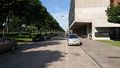
The Rijswijkse Landingslaan, the main road through the Ypenburg area. The hash is right ahead.
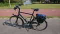
My bike parked exactly on the spot, just beside the bike path.
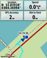
GPS proof.
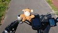
Lloyd celebrating.
Looking to the northeast. Ypenburg used to be an airfield, but it was closed in the early '90s and converted into a residential area. The main road through it (where we're standing now) used to be the runway.
Looking southwest.
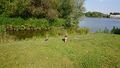
These Egyptian geese (Alopochen aegyptiaca) were making a lot of noise when I arrived, and were curious to know what this visitor was doing on their territory.


Achievements
FelixTheCat (talk) earned the Bicycle geohash achievement
|