Difference between revisions of "2022-07-02 34 -118"
From Geohashing
(add plans) |
m (Location) |
||
| (2 intermediate revisions by one other user not shown) | |||
| Line 1: | Line 1: | ||
| − | + | {{meetup graticule | |
| − | |||
| − | |||
| − | |||
| − | |||
| − | |||
| − | |||
| − | |||
| − | |||
| lat=34 | | lat=34 | ||
| lon=-118 | | lon=-118 | ||
| Line 14: | Line 6: | ||
__NOTOC__ | __NOTOC__ | ||
== Location == | == Location == | ||
| − | |||
In the front yard of 10275 Orton Ave, Los Angeles, CA 90064. | In the front yard of 10275 Orton Ave, Los Angeles, CA 90064. | ||
| Line 20: | Line 11: | ||
<!-- who attended: If you link to your wiki user name in this section, your expedition will be picked up by the various statistics generated for geohashing. You may use three tildes ~ as a shortcut to automatically insert the user signature of the account you are editing with. | <!-- who attended: If you link to your wiki user name in this section, your expedition will be picked up by the various statistics generated for geohashing. You may use three tildes ~ as a shortcut to automatically insert the user signature of the account you are editing with. | ||
--> | --> | ||
| + | * Jesse's LA mom | ||
== Plans == | == Plans == | ||
| − | |||
A first time geohasher is going to drive over and take a few pictures, which will then be uploaded by [[User:JesseFTW|JesseFTW]] ([[User talk:JesseFTW|talk]]). | A first time geohasher is going to drive over and take a few pictures, which will then be uploaded by [[User:JesseFTW|JesseFTW]] ([[User talk:JesseFTW|talk]]). | ||
== Expedition == | == Expedition == | ||
| − | + | My mom did make it over, right around 4 PM. She actually spoke with the homeowner who was out front with his kids on tricycles, and explained geohashing. He was amused, and fine with her taking pictures. It's a cul-du-sac, the kids often like to play in the street. -- [[User:JesseFTW|JesseFTW]] ([[User talk:JesseFTW|talk]]) 23:57, 2 July 2022 (UTC) | |
| − | |||
| − | |||
| − | |||
== Photos == | == Photos == | ||
| − | |||
| − | |||
| − | |||
<gallery perrow="5"> | <gallery perrow="5"> | ||
| + | File:2022-07-02 34 -118 person behind map.jpg | The hash point is in the front yard of this house. The geohasher is pictured, behind a map. | ||
| + | File:2022-07-02 34 -118 dead end.jpg | The street ends at a movie studio. | ||
</gallery> | </gallery> | ||
| Line 42: | Line 29: | ||
<!-- Add any achievement ribbons you earned below, or remove this section --> | <!-- Add any achievement ribbons you earned below, or remove this section --> | ||
| − | |||
| − | |||
| − | |||
| − | |||
| − | |||
| − | |||
| − | |||
| − | |||
| − | |||
| − | |||
| − | |||
| − | |||
| − | |||
| − | |||
[[Category:Expeditions]] | [[Category:Expeditions]] | ||
| − | |||
[[Category:Expeditions with photos]] | [[Category:Expeditions with photos]] | ||
| − | |||
| − | |||
| − | |||
| − | |||
| − | |||
[[Category:Coordinates reached]] | [[Category:Coordinates reached]] | ||
| − | + | {{location|US|CA|LO}} | |
| − | |||
| − | |||
| − | |||
| − | |||
| − | |||
| − | |||
| − | |||
| − | |||
| − | |||
| − | |||
| − | |||
| − | |||
| − | |||
| − | |||
| − | |||
| − | |||
| − | |||
Latest revision as of 03:42, 3 July 2022
| Sat 2 Jul 2022 in 34,-118: 34.0524589, -118.4160675 geohashing.info google osm bing/os kml crox |
Location
In the front yard of 10275 Orton Ave, Los Angeles, CA 90064.
Participants
- Jesse's LA mom
Plans
A first time geohasher is going to drive over and take a few pictures, which will then be uploaded by JesseFTW (talk).
Expedition
My mom did make it over, right around 4 PM. She actually spoke with the homeowner who was out front with his kids on tricycles, and explained geohashing. He was amused, and fine with her taking pictures. It's a cul-du-sac, the kids often like to play in the street. -- JesseFTW (talk) 23:57, 2 July 2022 (UTC)
Photos
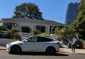
The hash point is in the front yard of this house. The geohasher is pictured, behind a map.
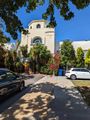
The street ends at a movie studio.

