Difference between revisions of "2022-07-08 44 -120"
Michael5000 (talk | contribs) (→Photos) |
Michael5000 (talk | contribs) (→Achievements) |
||
| Line 47: | Line 47: | ||
== Achievements == | == Achievements == | ||
{{#vardefine:ribbonwidth|800px}} | {{#vardefine:ribbonwidth|800px}} | ||
| − | |||
| − | |||
| − | |||
| − | |||
| − | |||
| − | |||
| − | |||
| − | |||
| − | |||
| − | |||
| − | |||
| − | |||
| − | |||
| − | |||
| − | |||
| − | |||
[[Category:Expeditions]] | [[Category:Expeditions]] | ||
| − | |||
[[Category:Expeditions with photos]] | [[Category:Expeditions with photos]] | ||
| − | |||
| − | |||
| − | |||
| − | |||
| − | |||
[[Category:Coordinates reached]] | [[Category:Coordinates reached]] | ||
| − | |||
| − | |||
| − | |||
| − | |||
| − | |||
| − | |||
| − | |||
| − | |||
| − | |||
| − | |||
| − | |||
| − | |||
| − | |||
| − | |||
| − | |||
| − | |||
| − | |||
| − | |||
Revision as of 18:12, 10 July 2022
| Fri 8 Jul 2022 in 44,-120: 44.6115230, -120.2101686 geohashing.info google osm bing/os kml crox |
Location
On a little hill off of Burnt Ridge Road, northwest of Mitchell.
Participants
Expedition
After 2022-07-08 45 -120, we turned south towards terrific scenery instead of north towards home, and then drove across the wheatlands of north central Oregon, stopping in Condon -- one of my favorite small towns anywhere -- for gas. Then we continued through Fossil, then again up and over into little Mitchell, where we caught US 26. A few miles later we found Burnt Ranch Road, and another mile or two led us to a little turnout. We were only 400 feet (~130 meters) from the hashpoint!
A problem you sometimes run into with rural geohashing, even in our incredibly information-rich age, is that it can be hard to judge elevation changes from the satellite images. I was right that we'd have open, unfenced terrain -- but was surprised to see that it was going to be on the top of a not-insignificant little hill. Fortunately, we are intrepid and stalwart and all that, so we began climbing. We were rewarded with fine views as well as well as the usual pot of gold that one finds at every hashpoint.
When I drive by a little hill, I often think that it would be grand to stop and climb it. It's fun that I actually had a reason to do so this time!
Having come this far, it seemed reasonable to head west to 2022-07-08 44 -121.
Photos
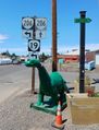
Passing through dear old Condon along the way.
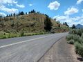
The hashpoint is near the top of that little hill, which doesn't look like much from the car.
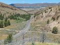
But, the car sure looks tiny from that hill!
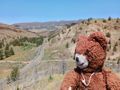
The hashcot has been underrepresented as of late.
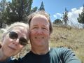
We, the geohashing humans.
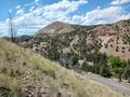
Another view from the hashpoint, because scenery.
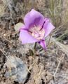
Scenery at another scale.
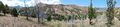
Panoramic scenery.


