Difference between revisions of "2022-07-24 50 8"
Gefrierbrand (talk | contribs) ([retro picture]sunrise) |
Gefrierbrand (talk | contribs) |
||
| Line 1: | Line 1: | ||
| − | + | {{meetup graticule | |
| − | |||
| − | |||
| − | |||
| − | |||
| − | |||
| − | |||
| − | |||
| − | |||
| lat=50 | | lat=50 | ||
| lon=8 | | lon=8 | ||
| date=2022-07-24 | | date=2022-07-24 | ||
| − | }} | + | }} |
__NOTOC__ | __NOTOC__ | ||
== Location == | == Location == | ||
| − | + | In a forest near Kemel | |
== Participants == | == Participants == | ||
| − | + | *[[User:Gefrierbrand|Gefrierbrand]] | |
| − | + | *[[User:Santu|Santu]] | |
| − | + | *Pedro the dog | |
== Plans == | == Plans == | ||
| − | + | We did not intend to go Geohashing there (or even at all for this day), but this changed quite drastically... | |
== Expedition == | == Expedition == | ||
| − | + | Due to some unfortunate events, we had to travel the same route several times in different directions. Reluctantly, we decided if we are on the road anyway, we might was well make the most out of it and go on a Geohashingadventure along the way. | |
| − | + | Having decided that this would be a good idea, we somehow also concluded that getting up at 4:00 AM in the morning to be able to claim the sunrise-achievement was an even better idea. So we slept very little, were groaning very much and woke up the very surprised dog much earlier than usual before driving towards our destination. | |
| − | + | ||
| + | Fortunately we did not have to venture too far from our route and were able to enjoy a very beautiful view in the dawn. The lighting was somewhat strange and we got a really surreal feeling from all those wind-turbines quietly rotating and blinking. | ||
| + | |||
| + | We were able to reach the destination without any trouble a few minutes before sunrise, set up a nice picnic there and simply waited for the sun to show up before we continued along our journey. | ||
== Photos == | == Photos == | ||
| − | |||
| − | |||
| − | |||
<gallery perrow="5"> | <gallery perrow="5"> | ||
| − | |||
| − | |||
| − | |||
Image:2022-07-24_50_8_Gefrierbrand_1659279818161.jpg|nice view | Image:2022-07-24_50_8_Gefrierbrand_1659279818161.jpg|nice view | ||
| − | + | Image:2022-07-24_50_8_Gefrierbrand_1659279849174.jpg|StupidGrin<sup>TM</sup> | |
| − | Image:2022-07-24_50_8_Gefrierbrand_1659279849174.jpg| | ||
| − | |||
Image:2022-07-24_50_8_Gefrierbrand_1659279883440.jpg|sunrise | Image:2022-07-24_50_8_Gefrierbrand_1659279883440.jpg|sunrise | ||
| + | Image:2022-07-24_50_8_Gefrierbrand_1659279636985.jpg|Proof | ||
</gallery> | </gallery> | ||
== Achievements == | == Achievements == | ||
{{#vardefine:ribbonwidth|800px}} | {{#vardefine:ribbonwidth|800px}} | ||
| − | + | {{land geohash | |
| − | + | | latitude = 50 | |
| − | + | | longitude = 8 | |
| − | + | | date = 22-07-24 | |
| − | + | | name = Gefrierbrand & Santu | |
| − | + | }} | |
| − | + | {{Sunrise geohash | |
| − | + | | latitude = 50 | |
| − | + | | longitude = 8 | |
| − | + | | date = 22-07-24 | |
| − | + | | name = Santu & Gefrierbrand | |
| − | + | }} | |
| − | + | {{Picnic_geohash | |
| − | + | | latitude = 50 | |
| − | + | | longitude = 8 | |
| − | + | | date = 22-07-24 | |
| + | }} | ||
[[Category:Expeditions]] | [[Category:Expeditions]] | ||
| − | |||
[[Category:Expeditions with photos]] | [[Category:Expeditions with photos]] | ||
| − | |||
| − | |||
| − | |||
| − | |||
| − | |||
[[Category:Coordinates reached]] | [[Category:Coordinates reached]] | ||
| − | |||
| − | |||
| − | |||
| − | |||
| − | |||
| − | |||
| − | |||
| − | |||
| − | |||
| − | |||
| − | |||
| − | |||
| − | |||
| − | |||
| − | |||
| − | |||
| − | |||
| − | |||
Revision as of 09:03, 10 August 2022
| Sun 24 Jul 2022 in 50,8: 50.1676702, 8.0266261 geohashing.info google osm bing/os kml crox |
Location
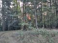
In a forest near Kemel
Participants
- Gefrierbrand
- Santu
- Pedro the dog
Plans
We did not intend to go Geohashing there (or even at all for this day), but this changed quite drastically...
Expedition
Due to some unfortunate events, we had to travel the same route several times in different directions. Reluctantly, we decided if we are on the road anyway, we might was well make the most out of it and go on a Geohashingadventure along the way.
Having decided that this would be a good idea, we somehow also concluded that getting up at 4:00 AM in the morning to be able to claim the sunrise-achievement was an even better idea. So we slept very little, were groaning very much and woke up the very surprised dog much earlier than usual before driving towards our destination.
Fortunately we did not have to venture too far from our route and were able to enjoy a very beautiful view in the dawn. The lighting was somewhat strange and we got a really surreal feeling from all those wind-turbines quietly rotating and blinking.
We were able to reach the destination without any trouble a few minutes before sunrise, set up a nice picnic there and simply waited for the sun to show up before we continued along our journey.
Photos
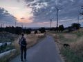
nice view
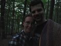
StupidGrinTM
sunrise
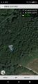
Proof


Achievements
Gefrierbrand & Santu earned the Land geohash achievement
|
Santu & Gefrierbrand earned the Sunrise Geohash Achievement
|
This user earned the Picnic achievement
|