Difference between revisions of "2022-07-27 52 4"
FelixTheCat (talk | contribs) (Created page with "{{subst:Expedition |lat = 52 |lon = 4 |date = 2022-07-27 }}") |
FelixTheCat (talk | contribs) |
||
| Line 1: | Line 1: | ||
| − | + | {{meetup graticule | |
| − | |||
| − | |||
| − | |||
| − | |||
| − | |||
| − | |||
| − | |||
| − | |||
| lat=52 | | lat=52 | ||
| lon=4 | | lon=4 | ||
| Line 14: | Line 6: | ||
__NOTOC__ | __NOTOC__ | ||
== Location == | == Location == | ||
| − | + | Between two greenhouses in Nootdorp, South Holland province. | |
== Participants == | == Participants == | ||
| − | + | *[[User:FelixTheCat|FelixTheCat]] ([[User talk:FelixTheCat|talk]]) | |
| − | + | *Kat the Awesome | |
| − | |||
| − | |||
| − | |||
== Expedition == | == Expedition == | ||
| − | + | Today's hash was in Nootdorp, on a path between two greenhouses. The weather was nice, so we decided to bike there in the evening. The hash was next to a narrow footpath along a ditch, so we walked the last bit. From the satellite pictures it seemed like the point was right on the edge of the water, and I had to lean over the water a bit to reach the point. We then took a few pictures and rode back home again. There were some menacing clouds, but it didn't rain. | |
| − | |||
| − | |||
| − | |||
== Photos == | == Photos == | ||
| − | |||
| − | |||
| − | |||
<gallery perrow="5"> | <gallery perrow="5"> | ||
| + | Image:2022-07-27 52 4 FelixTheCat 1.JPG | Riding along Holland's beautifully maintained bike paths. | ||
| + | Image:2022-07-27 52 4 FelixTheCat 2.JPG | The hash street. The point is about a hundred metres ahead on the right. Note the upside-down flag hanging from the lamppost: it's a symbol of the [https://en.wikipedia.org/wiki/Dutch_farmers_protests ongoing farmers' protests against emissions regulations]. | ||
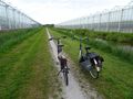
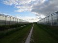
| + | Image:2022-07-27 52 4 FelixTheCat 3.JPG | The hash path. The point is up ahead, near where those people are walking their dogs. The path is apparently named after Nol van de Sande, a local politician. | ||
| + | Image:2022-07-27 52 4 FelixTheCat 4.JPG | I can just about reach the point. | ||
| + | Image:2022-07-27 52 4 FelixTheCat 5.png | GPS proof. | ||
| + | Image:2022-07-27 52 4 FelixTheCat 6.JPG | Lloyd, Templeton, Lleroy and Hermelien celebrate another success. | ||
| + | Image:2022-07-27 52 4 FelixTheCat 7.JPG | Our bikes next to the hash. | ||
| + | Image:2022-07-27 52 4 FelixTheCat 8.JPG | Looking east. Both greenhouses are used to grow bell peppers. | ||
| + | Image:2022-07-27 52 4 FelixTheCat 9.JPG | Looking west. | ||
</gallery> | </gallery> | ||
== Achievements == | == Achievements == | ||
{{#vardefine:ribbonwidth|800px}} | {{#vardefine:ribbonwidth|800px}} | ||
| − | + | {{bicycle geohash | |
| − | + | | latitude = 52 | |
| − | + | | longitude = 4 | |
| − | + | | date = 2022-07-27 | |
| − | [[ | + | | name = [[User:FelixTheCat|FelixTheCat]] ([[User talk:FelixTheCat|talk]]) and Kat |
| − | + | | distance = 12.9 km | |
| − | + | | bothways = true | |
| − | + | }} | |
| − | |||
| − | |||
| − | [[ | ||
| − | |||
| − | |||
| − | |||
| − | |||
| − | |||
[[Category:Expeditions]] | [[Category:Expeditions]] | ||
| − | |||
[[Category:Expeditions with photos]] | [[Category:Expeditions with photos]] | ||
| − | |||
| − | |||
| − | |||
| − | |||
| − | |||
[[Category:Coordinates reached]] | [[Category:Coordinates reached]] | ||
| − | |||
| − | |||
| − | |||
| − | |||
| − | |||
| − | |||
| − | |||
| − | |||
| − | |||
| − | |||
| − | |||
| − | |||
| − | |||
| − | |||
| − | |||
| − | |||
| − | |||
| − | |||
Revision as of 17:10, 29 July 2022
| Wed 27 Jul 2022 in 52,4: 52.0427699, 4.4243738 geohashing.info google osm bing/os kml crox |
Location
Between two greenhouses in Nootdorp, South Holland province.
Participants
- FelixTheCat (talk)
- Kat the Awesome
Expedition
Today's hash was in Nootdorp, on a path between two greenhouses. The weather was nice, so we decided to bike there in the evening. The hash was next to a narrow footpath along a ditch, so we walked the last bit. From the satellite pictures it seemed like the point was right on the edge of the water, and I had to lean over the water a bit to reach the point. We then took a few pictures and rode back home again. There were some menacing clouds, but it didn't rain.
Photos
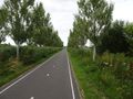
Riding along Holland's beautifully maintained bike paths.
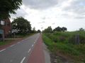
The hash street. The point is about a hundred metres ahead on the right. Note the upside-down flag hanging from the lamppost: it's a symbol of the ongoing farmers' protests against emissions regulations.
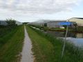
The hash path. The point is up ahead, near where those people are walking their dogs. The path is apparently named after Nol van de Sande, a local politician.
I can just about reach the point.
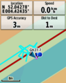
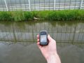
GPS proof.
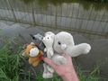
Lloyd, Templeton, Lleroy and Hermelien celebrate another success.
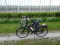
Our bikes next to the hash.
Looking east. Both greenhouses are used to grow bell peppers.
Looking west.


Achievements
FelixTheCat (talk) and Kat earned the Bicycle geohash achievement
|