2022-08-03 42 -78
| Wed 3 Aug 2022 in 42,-78: 42.9387439, -78.5117632 geohashing.info google osm bing/os kml crox |
Location
Corner of Peters Corners Rd and Railroad Tracks in Alden
Participants
Expedition
I saw this was likely reachable and I didn't have a whole lot going on in the evening, so I figured I'd give it a try and make a Consecutive Streak. You can read about yesterday's expedition here.
I'm writing up this expedition late, so I don't remember exactly what happened, and reviewing the pictures, I don't see Simon in the back of the car, but I'm pretty sure I took him and we went for a hike afterwords at Darien Lakes State Park. I just don't have any pictures from that hike. Anyway...
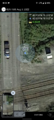
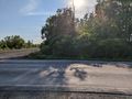
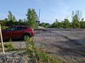
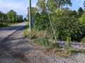
I had an uneventful drive to the hash after work, following my phone's GPS. Getting to the train tracks, I was able to pull off the road in a very wide area next to the tracks and next to some kind of shed. Since it was right next to the road and it would just be a stop for 2 seconds, if I did have Simon with me, I left him in the car. I was able to do a short GPS dance and get a good reading from the road fortunately. I would not have been able to go too far off the road as the ditch was probably 2 meters deep, very steep and had a LOT of standing water down there. Getting my pictures, I headed back to the car.
I'm 95% sure I had Simon, because Darien Lakes was right there and we would be able to justify a long drive with a hike and I would definitely want to take him there. I recall missing my turn as I had planned on parking on the eastern side of the property and walk down the old road paths, but realizing I missed my turn, I was looking for a place to turn around and I saw the parking area for the other side of the park where the Finger Lakes trail goes through. This worked out because it was likely less populated and I could possibly explore a trail I've walked by many times but never went down. I set my alarm for an hour or so and we headed down the trail. The Red trail was closer than I remembered from this side and I'm glad we explored that area. It twisted and looped around near the creek that goes through there and headed toward the camping area of the park. My alarm went off to turn around before I found the end of the trail, but it was a very cool hike! Will definitely need to explore the rest of that trail when I have time.
Photos
Made it!
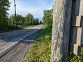
View North from the hash.
View West.
View South and of the hash-mobile.

Standard Stupid Grin.
View of the hash from where I parked.
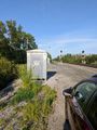
View down the tracks. No trains today.


Ribbons
This user earned the Land geohash achievement
|
Pedalpusher earned the Consecutive geohash achievement
|