Difference between revisions of "2022-08-04 48 16"
From Geohashing
Gefrierbrand (talk | contribs) ([retro picture]Formal hats) |
Gefrierbrand (talk | contribs) ([retro picture]steep) |
||
| Line 38: | Line 38: | ||
Image:2022-08-04_48_16_Gefrierbrand_1660122623302.jpg|Formal hats | Image:2022-08-04_48_16_Gefrierbrand_1660122623302.jpg|Formal hats | ||
| + | |||
| + | Image:2022-08-04_48_16_Gefrierbrand_1660122787678.jpg|steep | ||
</gallery> | </gallery> | ||
Revision as of 09:13, 10 August 2022
| Thu 4 Aug 2022 in 48,16: 48.0743150, 16.1329817 geohashing.info google osm bing/os kml crox |
Location
on the edge of a forest path near Dornbach
Participants
Plans
Expedition
Tracklog
Photos
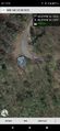
proof

Formal hats
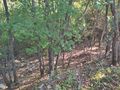
steep


Achievements