Difference between revisions of "2022-08-04 48 16"
Gefrierbrand (talk | contribs) |
Gefrierbrand (talk | contribs) |
||
| Line 6: | Line 6: | ||
__NOTOC__ | __NOTOC__ | ||
== Location == | == Location == | ||
| − | + | On the edge of a forest path near Dornbach | |
== Participants == | == Participants == | ||
| + | *[[User:Santu|Santu]] | ||
| + | *[[User:Gefrierbrand|Gefrierbrand]] | ||
| + | == Expedition == | ||
| + | After the failed attempt to reach a geohash in Austria [[2021-08-04 48 16|last year]], we tried again exactly one year later and this time were successful. | ||
| + | Because of the very hot weather we decided to leave Pedro at "home" with relatives and ventured on alone (missing him the entire way). | ||
| + | The hash was located only a few kilometers away from our hotel and we had no trouble reaching it, but may (or may not) have used [https://xkcd.com/207/ questionably legal maneuvers] to get there. As so often before, the area was quite hilly and we were very fortunate to find the hash right on the edge of a forest road right before a steep slope. | ||
| − | + | As we had visited a ceremony before, we were still wearing nice clothes including fancy hats which made us look like badass gangsters, but also lets us finally claim the formal attire achievement. | |
| − | |||
| − | |||
== Photos == | == Photos == | ||
| Line 20: | Line 24: | ||
<gallery perrow="5"> | <gallery perrow="5"> | ||
Image:2022-08-04_48_16_Gefrierbrand_1660122846081.jpg|nice landscape | Image:2022-08-04_48_16_Gefrierbrand_1660122846081.jpg|nice landscape | ||
| − | Image:2022-08-04_48_16_Gefrierbrand_1660122623302.jpg|StupidGrin<sup>TM</sup> with | + | Image:2022-08-04_48_16_Gefrierbrand_1660122623302.jpg|StupidGrin<sup>TM</sup> with formal hats |
Image:2022-08-04_48_16_Gefrierbrand_1660122787678.jpg|Steep terrain right next to the hash | Image:2022-08-04_48_16_Gefrierbrand_1660122787678.jpg|Steep terrain right next to the hash | ||
Image:2022-08-04_48_16_Gefrierbrand_1659629382907.jpg|proof | Image:2022-08-04_48_16_Gefrierbrand_1659629382907.jpg|proof | ||
| Line 27: | Line 31: | ||
== Achievements == | == Achievements == | ||
{{#vardefine:ribbonwidth|800px}} | {{#vardefine:ribbonwidth|800px}} | ||
| − | + | {{land geohash | |
| − | + | | latitude = 48 | |
| − | + | | longitude = 16 | |
| − | + | | date =2022-08-04 | |
| − | + | | name = Santu & Gefrierbrand | |
| + | }} | ||
| + | {{Formal attire | ||
| + | | latitude = 48 | ||
| + | | longitude = 16 | ||
| + | | date =2022-08-04 | ||
| + | | name = Santu & Gefrierbrand | ||
| + | }} | ||
| − | |||
| − | |||
| − | |||
| − | |||
| − | |||
| − | |||
| − | |||
| − | |||
| − | |||
| − | |||
[[Category:Expeditions]] | [[Category:Expeditions]] | ||
| − | |||
[[Category:Expeditions with photos]] | [[Category:Expeditions with photos]] | ||
| − | |||
| − | |||
| − | |||
| − | |||
| − | |||
[[Category:Coordinates reached]] | [[Category:Coordinates reached]] | ||
| − | |||
| − | |||
| − | |||
| − | |||
| − | |||
| − | |||
| − | |||
| − | |||
| − | |||
| − | |||
| − | |||
| − | |||
| − | |||
| − | |||
| − | |||
| − | |||
| − | |||
| − | |||
Revision as of 11:12, 10 August 2022
| Thu 4 Aug 2022 in 48,16: 48.0743150, 16.1329817 geohashing.info google osm bing/os kml crox |
Location
On the edge of a forest path near Dornbach
Participants
Expedition
After the failed attempt to reach a geohash in Austria last year, we tried again exactly one year later and this time were successful. Because of the very hot weather we decided to leave Pedro at "home" with relatives and ventured on alone (missing him the entire way).
The hash was located only a few kilometers away from our hotel and we had no trouble reaching it, but may (or may not) have used questionably legal maneuvers to get there. As so often before, the area was quite hilly and we were very fortunate to find the hash right on the edge of a forest road right before a steep slope.
As we had visited a ceremony before, we were still wearing nice clothes including fancy hats which made us look like badass gangsters, but also lets us finally claim the formal attire achievement.
Photos
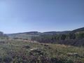
nice landscape

StupidGrinTM with formal hats
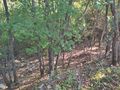
Steep terrain right next to the hash
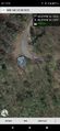
proof


Achievements
Santu & Gefrierbrand earned the Land geohash achievement
|
Santu & Gefrierbrand earned the Formal attire achievement
|