Difference between revisions of "2022-09-10 42 -71"
From Geohashing
(add location and plans) |
([live picture]Made it there, here's the requsite Silly Grin. [https://openstreetmap.org/?mlat=42.26879490&mlon=-71.14043890&zoom=16 @42.2688,-71.1404]) |
||
| Line 36: | Line 36: | ||
--> | --> | ||
<gallery perrow="5"> | <gallery perrow="5"> | ||
| + | |||
| + | Image:2022-09-10_42_-71_JesseFTW_1662835100959.jpg|Made it there, here's the requsite Silly Grin. [https://openstreetmap.org/?mlat=42.26879490&mlon=-71.14043890&zoom=16 @42.2688,-71.1404] | ||
</gallery> | </gallery> | ||
Revision as of 18:38, 10 September 2022
| Sat 10 Sep 2022 in 42,-71: 42.2687810, -71.1404388 geohashing.info google osm bing/os kml crox |
Location
Just off the path near Bearberry Hill in the Stony Brook Reservation near Hyde Park & West Roxbury; accessible(ish) via Providence/Stoughton Line on the MBTA Commuter Rail.
Participants
Plans
JesseFTW (talk): Intending to make it out there sometime on Saturday, maybe close to 4 PM if possible. It'd be great if any other local geohashers wanted to meet up!
Expedition
Tracklog
Photos
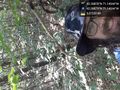
Made it there, here's the requsite Silly Grin. @42.2688,-71.1404

Achievements