| Tue 20 Sep 2022 in 51,10: 51.3306504, 10.0007332 geohashing.info google osm bing/os kml crox |
Location
On a field north of Fretterode
Participants
Plans
Do a little walk to the hash before going to work...
Expedition
Todays hash was located on a field or meadow between Gerbershausen and Fretterode in Thuringia and I decided to park my car in the latter village to walk to the hash from there. The 1,2 km hike was pretty easy but got little uphill all the time. Onyl some 200 meters before the hash, I reached the hightest point and from there, I could see where the hash was - and I also noticed a lot of cows on that same field! That moment, I knew this was going to be an unsuccesful expedition hehe... Still, I tried to get as close as possible, which were only 10 meters from the hash. I could have gone through those bushes but behind it, there was this electric fence and then there would still be some 5 meters between me and the hash. So, I simply took some pics for evidence and continued my walk through the woods to end up finding two recently published geocaches. After exactly one hour and 6 km, I got back to my car and drove home, satisfied anyway!
Photos
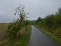
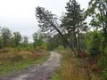
On my way to the hash
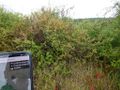
The hash was behind those bushes
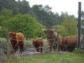
Curious cows
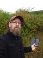
The hasher at the hash location
On my way back
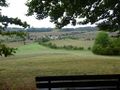
Nice view on Fretterode
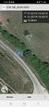
Proof


