Difference between revisions of "2022-09-25 51 4"
FelixTheCat (talk | contribs) (Created page with "{{subst:Expedition |lat = 51 |lon = 4 |date = 2022-09-25 }}") |
FelixTheCat (talk | contribs) |
||
| Line 1: | Line 1: | ||
| − | + | {{meetup graticule | |
| − | |||
| − | |||
| − | |||
| − | |||
| − | |||
| − | |||
| − | |||
| − | |||
| lat=51 | | lat=51 | ||
| lon=4 | | lon=4 | ||
| date=2022-09-25 | | date=2022-09-25 | ||
| − | }} | + | }} |
== Location == | == Location == | ||
| − | + | Hammerfeststraat, Rotterdam, South Holland province. | |
== Participants == | == Participants == | ||
| − | + | * [[User:FelixTheCat|FelixTheCat]] ([[User talk:FelixTheCat|talk]]) | |
| − | + | * Kat the Awesome | |
| − | |||
| − | |||
| − | |||
== Expedition == | == Expedition == | ||
| − | + | Today's hash was on the street in a residential area in Rotterdam. Kat and I were planning to visit family in Rotterdam anyway, so we only needed a small detour to visit the hash. We parked the hashmobile in Stavangererf, right next to Hammerfeststraat. As in nearly all post-war neighbourhoods, street names in this area follow a theme, in this case Norwegian cities. We walked towards the hash and found it without trouble. We then got back in the hashmobile and went on our way. | |
| − | |||
| − | |||
| − | |||
== Photos == | == Photos == | ||
| − | |||
| − | |||
| − | |||
<gallery perrow="5"> | <gallery perrow="5"> | ||
| + | Image:2022-09-25 51 4 FelixTheCat 1.JPG | Looking down the first bit of Hammerfeststraat. Stavangererf is on the right. | ||
| + | Image:2022-09-25 51 4 FelixTheCat 2.JPG | The hash tree. | ||
| + | Image:2022-09-25 51 4 FelixTheCat 3.JPG | Another view of the hash tree. The street behind it is called "Evenaar", which means "Equator". It links several areas with streets named after cities around the world. | ||
| + | Image:2022-09-25 51 4 FelixTheCat 4.png | GPS proof. | ||
| + | Image:2022-09-25 51 4 FelixTheCat 5.JPG | Lleroy, Lloyd and Kuikie celebrating. | ||
</gallery> | </gallery> | ||
== Achievements == | == Achievements == | ||
{{#vardefine:ribbonwidth|100%}} | {{#vardefine:ribbonwidth|100%}} | ||
| − | + | {{land geohash | |
| − | + | | latitude = 51 | |
| + | | longitude = 4 | ||
| + | | date = 2022-09-25 | ||
| + | | name = [[User:FelixTheCat|FelixTheCat]] ([[User talk:FelixTheCat|talk]]) and Kat | ||
| + | }} | ||
__NOTOC__ | __NOTOC__ | ||
| − | |||
| − | |||
| − | |||
| − | |||
| − | |||
| − | |||
| − | |||
| − | |||
[[Category:Expedition planning]] | [[Category:Expedition planning]] | ||
| − | |||
| − | |||
| − | |||
| − | |||
| − | |||
[[Category:Expeditions]] | [[Category:Expeditions]] | ||
| − | |||
[[Category:Expeditions with photos]] | [[Category:Expeditions with photos]] | ||
| − | |||
| − | |||
| − | |||
| − | |||
| − | |||
[[Category:Coordinates reached]] | [[Category:Coordinates reached]] | ||
| − | |||
| − | |||
| − | |||
| − | |||
| − | |||
| − | |||
| − | |||
| − | |||
| − | |||
| − | |||
| − | |||
| − | |||
| − | |||
| − | |||
| − | |||
| − | |||
| − | |||
| − | |||
Revision as of 19:10, 26 September 2022
| Sun 25 Sep 2022 in 51,4: 51.9447722, 4.5640479 geohashing.info google osm bing/os kml crox |
Location
Hammerfeststraat, Rotterdam, South Holland province.
Participants
- FelixTheCat (talk)
- Kat the Awesome
Expedition
Today's hash was on the street in a residential area in Rotterdam. Kat and I were planning to visit family in Rotterdam anyway, so we only needed a small detour to visit the hash. We parked the hashmobile in Stavangererf, right next to Hammerfeststraat. As in nearly all post-war neighbourhoods, street names in this area follow a theme, in this case Norwegian cities. We walked towards the hash and found it without trouble. We then got back in the hashmobile and went on our way.
Photos
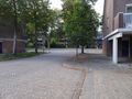
Looking down the first bit of Hammerfeststraat. Stavangererf is on the right.
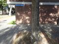
The hash tree.
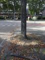
Another view of the hash tree. The street behind it is called "Evenaar", which means "Equator". It links several areas with streets named after cities around the world.
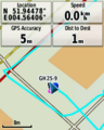
GPS proof.
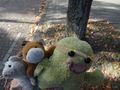
Lleroy, Lloyd and Kuikie celebrating.


Achievements
FelixTheCat (talk) and Kat earned the Land geohash achievement
|