Difference between revisions of "2023-06-01 42 -82"
From Geohashing
(→Location) |
m (Location) |
||
| (6 intermediate revisions by 2 users not shown) | |||
| Line 19: | Line 19: | ||
== Plans == | == Plans == | ||
| − | + | This hash was only a 13 km trip from my house and easily accessible, so I decided to bike over. | |
== Expedition == | == Expedition == | ||
| − | + | It was hot and sunny, but the trip was pleasant, and almost entirely on paved roads. | |
== Tracklog == | == Tracklog == | ||
| − | + | {{tracklog | 2023-06-01_42_-82.gpx}} | |
== Photos == | == Photos == | ||
| Line 33: | Line 33: | ||
<gallery perrow="5"> | <gallery perrow="5"> | ||
| − | Image:2023-06-01_42_-82_argilo_1685660697117.jpg| | + | Image:2023-06-01_42_-82_argilo_1685660697117.jpg|Looking North along Olinda Sideroad. [https://openstreetmap.org/?mlat=42.10081389&mlon=-82.67047778&zoom=16 @42.1008,-82.6705] |
</gallery> | </gallery> | ||
| Line 41: | Line 41: | ||
__NOTOC__ | __NOTOC__ | ||
| − | |||
| − | |||
| − | |||
| − | |||
| − | |||
| − | |||
| − | |||
| − | |||
| − | |||
| − | |||
| − | |||
| − | |||
| − | |||
| − | |||
[[Category:Expeditions]] | [[Category:Expeditions]] | ||
| − | |||
[[Category:Expeditions with photos]] | [[Category:Expeditions with photos]] | ||
| − | |||
| − | |||
| − | |||
| − | |||
| − | |||
[[Category:Coordinates reached]] | [[Category:Coordinates reached]] | ||
| − | + | {{location|CA|ON|ES}} | |
| − | |||
| − | |||
| − | |||
| − | |||
| − | |||
| − | |||
| − | |||
| − | |||
| − | |||
| − | |||
| − | |||
| − | |||
| − | |||
| − | |||
| − | |||
| − | |||
| − | |||
Latest revision as of 20:45, 7 July 2023
| Thu 1 Jun 2023 in 42,-82: 42.1007845, -82.6704596 geohashing.info google osm bing/os kml crox |
Location
Right on Olinda Sideroad, just North of Concession 6 Road in Kingsville, ON.
Participants
Plans
This hash was only a 13 km trip from my house and easily accessible, so I decided to bike over.
Expedition
It was hot and sunny, but the trip was pleasant, and almost entirely on paved roads.
Tracklog
Photos
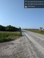
Looking North along Olinda Sideroad. @42.1008,-82.6705
