2008-08-05 -35 149/note
This was a the note left by Psud at the property containing the 2008-08-05 -35 149 hash point.
The Note
Hi!
You have the excellent fortune to have had a geohash point land approximately on your home. Actually it was a smidgeon north of your property line along Mirrabucca Crescent.
A “geohash” is a visit to a “geohash point”. A geohash point is a location worked out fairly randomly. Details are below if you’re interested.
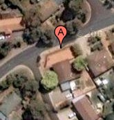
Anyway, the point of this letter is to let you know that your home now appears on an Internet page dedicated to the spot in your yard, and those who visited it today. A picture of where that spot is is shown to the right (that’s -35.2084245, 149.0909875 by latitude and longitude).
Being a Tuesday, it’s unlikely that many geohashers visited your side yard today (most geohashing occurs on a Saturday).
You can see who visited the geohash near your house by visiting 2008-08-05 -35 149 or by visiting wiki.xkcd.com/geohashing and navigating from there to “Active Graticules” then Canberra, Australia, then today’s date (Today, by the way is Tuesday 2008-08-05).
If you want to geohash To be a geohasher, simply visit a geohash point (look at the web page I pointed out above to find out where they are in future), and write about in on the page for that location. Also, you could (if you visited today’s geohash – in your side yard – be the first winner of the Couch Potato Geohash! See 2008-08-05 -35 149 )
How geohash locations are determined First you get the most recent opening price of the Dow Jones Industrial Average. For any particular weekday, that will have been made available half an hour before midnight the day before.
That is appended to the current date in format yyyy-mm-dd, so you end up with something like 2008-08-05-12345.67. You feed that into a “hash” algorithm named MD5. MD5 is commonly used to keep passwords secure. The resulting hash is a large number, usually represented in hexadecimal. That’s split in half. A decimal point is prepended, turning it into two very precise decimal fractions.
A person who wishes to geohash will then take those fractions and append them to their whole number latitude and longitude (Canberra’s entirely within -35 (latitude), 149 (longitude)). See “geo” from “earth” in that it gives you a point on the earth, “hash” because the point is determined by a hash algorithm. It’s pretty geeky.
Best Regards,
Psud, on behalf of The Internet.
