2008-09-22 -41 174
| Mon 22 Sep 2008 in Wellington: -41.2867028, 174.9586847 geohashing.info google osm bing/os kml crox |
About
This geohash appears to be on public land, but may well be in the middle of a patch of gorse. It's refreshing to see a hash somewhere near civilization in this graticule, though.
Expedition
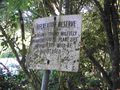
tjm1983: A bus could take me most of the distance from home to the hashpoint, so I decided to go that way. It dropped me off almost at the Willis Grove entrance to the Harry Todd Recreation Reserve, which I had to walk through to get to the hash; in fact, the boundaries of the reserve aren't clear, so the hash may actually be in the reserve.
The walk through the reserve was quite pleasant, and mostly gorse-free. Having said that, it was also quite steep, and consequently much windier than the map suggested. (By windier I mean twistier, not breezier; the trees were very good shelter from the wind.)
Since I couldn't rely on changes in the path's direction to help me figure out where I was, I had to rely on counting intersections. Unfortunately, this didn't work either. There just didn't seem to be enough intersections on the actual path to account for the intersections shown on the map; or maybe some of the paths joined up even though the map showed dead ends; or maybe the signs on the trail were lying. In any case, I didn't really know where I was, and it was hard even to use the sun to get a sense of what general direction I was going in, since I was turning corners so often.
Eventually, I found my way to a clearing with a couple of buildings joined together, and a couple of communications towers. The only building I'd noticed on the map was south of the hashpoint, so I thought I might have overshot it. I couldn't come up with any reasonable interpretation of the map that would have made that true, but by now I was willing to assume that the map just didn't know where the paths actually were.
There was a firebreak that came up to the clearing, but I wasn't in a mood to follow it very far, given how steep it was, and given that I didn't really know whether or not I'd already overshot the hashpoint. Also, the attempt had been much more effort than I'd anticipated, so if I'd gone further, I probably would have been too tired to get myself back home in reasonable time.
I took a break at the clearing, puzzled over the map some more, ate some food, juggled, and then headed back, not the way I came, but in a direction that (based on the signage) I was confident would take me to Hine Road, near the intersection with Coast Road. At an intersection on the way back, another sign affirmed my interpretation of reality. At that intersection, a couple of dogs came up, taking a man for a walk. All three were quite friendly, and the man further confirmed that my chosen route would take me where I thought it would, since he'd just come up that way. He couldn't figure out where on the map the buildings I'd seen were, but he knew where they were in real life.
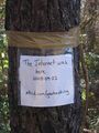
Further down the track on the way back, I attached my sign to a dead tree that was somewhere vaguely near where the hashpoint might have been, based on the assumption that I'd overshot it on the way up. I came out exactly where I thought I would, crossed a couple of roads, and went to the bus stop to wait for the next bus. As it turned out, the next bus was in about 30 seconds, which was fortunate, because I think they only come every half hour.
Walking back home from the bus stop at the other end, I saw a duck with too many ducklings to count while they were moving, so I paused to take a photo of them. There were four more ducklings following along behind, which would have made an enormous brood, but they were larger, and were perhaps unrelated ducklings going on one of their first adventures without their mother.
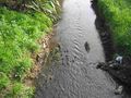
While I was standing on the footpath on the one-lane bridge, taking photos, a fire engine screamed past. I stood as close as I could to the railing, holding on tightly. In an apparently unrelated incident, a police car stopped by the stream. Two policemen got out, and asked me if I'd seen a scooter in the stream. I said I hadn't seen one, but I hadn't really been looking. They looked for one, but didn't seem to find one. Does it count as a Police Geohash if I didn't make it to the hashpoint?
Anyway, when I got home, I zoomed in on the sattelite images in various places, trying to find the clearing I'd stopped at. I hadn't overshot the hashpoint at all. I'd never got as far south at the hashpoint. There were still intersecting trails on the map that I'd never seen when I was there in person, and at least one intersection in real life that wasn't on the map (which I think is a sign that the dead end isn't really a dead end). In any case, with navigational skills like that, I don't think I'll be getting a No Batteries Geohash any time soon. Maybe I need to invest in one of those Neo Freerunners. Unfortunately, the GSM 900 variant seems to be hard to get your hands on, and that's the one I need if I want to use it as a phone in New Zealand.

On the bus. I don't always look that smudged.
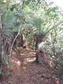
The track
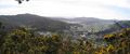
A rare gap through the trees along the track
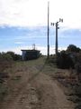
The scene at the clearing
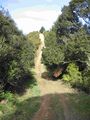
The firebreak leading away from the clearing; it seemed steeper in real life, at least after having just climbed up to the clearing

Having a bit of fun

Five grains still intact, or you get your money back
xkcd marks somewhere in the general vicinity of the spot
Good thing I attached the sign to a tree that was already dead
Eleven ducklings, I think?

I think he left the ducklings alone
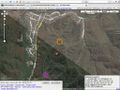
Pinky-purple: where I thought I might have been; orange: where I actually was


