2008-12-15 48 9
| Mon 15 Dec 2008 in Stuttgart, Germany: 48.6688231, 9.5552775 geohashing.info google osm bing/os kml crox |
Contents
About
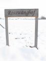
The hash is on a paddock of the Roßwanghof, a horse farm at Hattenhofen.
Expedition: Ekorren
This was a bit far to go in the winter with sunset around 16:30, and the chance to reach the point seemed to be a bit on the low side - but, after carefully discarding all sober second thoughts, I decided to go.
Into the great wide open...
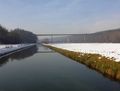
Neckar valley near Reutlingen-Altenburg
Neckar cycle trail bridge near Pliezhausen


As usual, I started a bit late for what laid before me and quite too early to be really awake. I went onto the famous Neckar valley cycle trail, a touristical long distance trail with a total length of about 400 km.
4.95 km - that was how far I came. Then I got, once again, a smaller problem with my bike but nothing that couldn't be fixed in no time with the tools I had with me. Just stop at the side, hold that, fasten thi... BANG. Tool broken, and hand wounded. Damn. Train wreck and Trail of Blood, two consolation prizes for the price of one.
Ok, let's see... isn't too bad. Can fix the bike so that it should make today's expedition with the broken tools, the hand... well, it's bloody, it hurt's, but it doesn't look any critical so I should be able to continue. Maybe buy some plaster in the next village.
Back on track, the next 40 km were uneventful, along a route I've already taken a few times before and that's only partly the recommended touristical trail.
At Wernau I crossed the river one last time.
... Under them skies of blue...
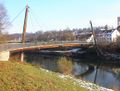
Pedestrians bridge at Wernau
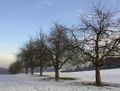
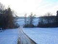
Near Notzingen-Wellingen


Now I got into unknown land - unknown to me, as I've never taken the turn out of the valley at Wernau before. As soon as I had crossed that town, a great changing landscape opened before me.
... Out in the great wide open...
It was too easy until now
Here we go
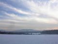
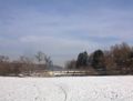
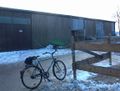
View from near Hattenhofen


Also it got colder again. I was surprised how much of a difference that made - down at Wernau the snow was mostly melted, the paths were dry, and the temperature was rather convenient. Now, only a few metres higher, everything was white again. And shortly after leaving Notzingen, the ice found me. I considered rerouting via main roads but there were no main roads to consider. There was just: Back, forward, or huge detours including some extra mountain. Which didn't sound convincing, and back isn't an option, so forward it was. And luckily, it got better again after a kilometre or something. Crossed Schlierbach and continued on the main road until near to the hash.
... A rebel without a clue.
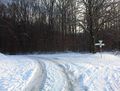
Here we are
This is where it ends
Been there, done whatever.


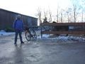
I came from the backside and could check for any kind of back entrance that would lead me to the hash, but there wasn't one. If there would be a way, it would be from the farm itself. So I entered from the main entrance - it was more or less public anyway since the horse boxes are hired out to external owners - and checked out the area. I could get a short glance, which wasn't very promising: Two fences in my way, or, choose if you like, one stable full of horses and with no appearent way through. So there was one last possibility, and that was the ambassador hash. But I found nobody I could ask.
After some waiting, a very old woman came out of one of the houses. As I had expected, she didn't understand a word of what I tried to explain to her, and therefor didn't like it (and me). With that she didn't have to do anything with the horses and thus was the wrong person to ask anyway, it was definitely a bad idea to ask her - because she now somehow observed me and tried to convince me to leave the farm. Which I finally did as the chance to find someone who would possibly be able to let me on the paddocks seemed pretty low. Also, I was running low on daylight time.
So I left the farm and went for the village, hoping to find a postcard this time. Failed again, as all shops which could probably stock postcards seemed to be closed.
I managed to reach the town of Kirchheim/Teck around sunset, which also had the nearest train station from where I could take a train back for a reasonable price, and as I didn't really fancy going back longer distances during dark in the winter with a high possibility of surprise ice, chose that option.
Bicycle geohash technical data:
Home -> hash: 59.35 km
Total length: 78.63 km (took train back)
Lowest point: ~255m at Wernau
Highest point: ~395m near Zell u.A.
Achievements
Didn't reach the hash, so there's only this consolation prize:
Ekorren earned the No trespassing consolation prize
|