2009-02-24 52 6
| Tue 24 Feb 2009 in 52,6: 52.2753339, 6.8536631 geohashing.info google osm bing/os kml crox |
Plan
Just like two days earlier, the hash was too close not to go for Arvid. On sunday there were some issues that prevented him from going though, but today was a good day. About 7km after work, and then about 9km back home. Since it only gets dark around 6pm around now, that can be done just before dark.
Achievements
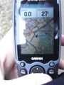
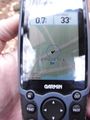
- Arvid cycled 17.4km
- No Trespassing.
Expedition
Arvid's tracklog by bicycle.
At 17:10 I left from work, with my old bike, which has no headlight anymore. This is partly because I expected quite some unpaved roads, as the ones I wanted to take aren't in google maps. That was correct. Most of them are also forbidden for cars/motorbikes. Quite a lot of them are part of recreational cycling routes though. Although unpaved, most of them were very good to ride on.
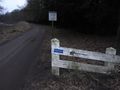
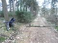
I got a bit of bad luck though. The road I wanted to take had 3 no trespassing signs. Are they trying to tell me something? This was around 17:25. I went home... but my route home went very close to the other possible route to the hash. It isn't getting dark yet, so let's try!
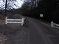
I went past the sign on the last picture. It says nothing at all about bikes, so let's assume I'm allowed in there. It does say I'm allowed on the paths. Since this is a nature reserve I shouldn't probably get off them then. In the end I came to another no trespassing sign. But that was as close I could get the hash on a track anyway. About 40m from the hash. Since I'm not allowed off the path(or at least that's what I think), still a no trespassing hash, but a nice ride through the woods anyway.
Around 17:40 I went home, arriving there just after 18:00. Just in time before sunset.
No Trespassing.
No Trespassing.
Location of that spot.

Sad hasher.
Second attempt.
More no trespassing.
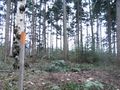
Hash is somewhere there.
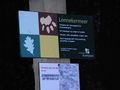
Lonnekermeer. Entrance between sunrise and sunset. Free walking on roads and paths. Dogs, when on a leash, are allowed. No entrance with motorvehicle, moped or horse. Furthermore no trespassing, some jurisdictional article.


