2009-04-20 51 -1
| Mon 20 Apr 2009 in Swindon, United Kingdom: 51.8570420, -1.2894693 geohashing.info google osm bing/os kml crox |
Today’s location was a little closer to Oxford than yesterday’s: just West of Bletchingdon on the B4027, somewhere in a field beside two small junctions either side of the road, according to the Google map. I thought this one should be much easier! I headed out on my bicycle with iPhone in pocket about 3PM, travelling North through the villages of Woodeaton, Islip and Bletchingdon. Islip is quite picturesque with lots of small winding streets and little bridges over little brooks. I passed a few family pubs and even a railway station, but the large number of ‘stop’ road markings makes me wonder if the village sees a lot of rush hour through-traffic.
I unknowingly flew past the hashpoint at first, and ended up on the A4095, going past another train line and ending up at a canal-side pub. As well as a bunch of beautiful longboats on the canal, in the distance were some parabolic antennae and a lonely factory with a single smoke-stack!
I thought I’d lost it and would have to be happy seeing that odd bunch of unrelated things in one place, but on the way back I noticed the very small right-hand junction followed shortly by an equally small left-hand junction that I’d seen on the map. I found the hashpoint, but I did not reach it. Turns out it was in a small field on my right just beyond a fenced-off box of trees, but I was put off by all the farmers tilling about in their tractors, the house right next to the field, and that the field was full of horses. I didn’t want anyone to think I was steeling his steed. Not to mention the bushes were high and mightily thorny.
—Forawhile 18:50, 20 April 2009 (UTC)
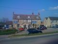
The Rock of Gibraltar, a nice canal-side pub
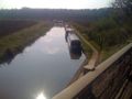
Longboats on the canal.
Antennae.
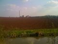
The Lonely Factory.
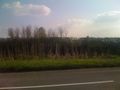
The hashpoint is somewhere past that box of trees, that impassable bush and those horses.
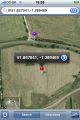
The red pin shows the hashpoint with GPS coordinates, and the purple pin, my location.
This estimate of my location really makes me want an iPhone 3G.

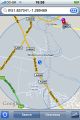
The rough distance and directions there, I took this route.


