2009-07-03 40 -74
| Fri 3 Jul 2009 in 40,-74: 40.0890544, -74.4062980 geohashing.info google osm bing/os kml crox |
Participants
Plans
The hash coordinates were in the woods a few hundred feet from the road, so it was very likely to be out of bounds. Zubenelgenubi was going to shoot for the geohash anyway, to explore the bikeability of a potential future route to Toms River.
Expedition
Shortly before reaching the hashpoint, it became clear from the echo of gunfire that going for the geohash coordinates would be particularly inadvisable. The woods were the territory of the Central Jersey Rifle and Pistol club. While the shooting ranges were not visible at all and probably much further from the road than the hashpoint, the report of pistols was quite loud at the roadside. Other than Fort Dix, there are not many hash points which would be worse to visit.
It would have been fun to shoot four targets with a clip each with the letters "xkcd" but I am both not a member of the club, and a very poor shot, so I just shot a few photographs and headed on.
Photos
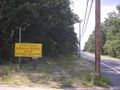
The unwelcoming grounds
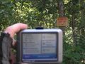
Some distance short of the coordinates

Mugging for the KEEP OFF sign
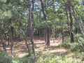
This part of northern Ocean county is just near the transition to Pine Barrens. Much of the forest is deciduous near the road turning into open pine further back.

One of two Russian Orthodox churches within 3 miles of the hash point, an unexpected sight in this rural area.


